You are here: Home > Network List > TA - USArray Transportable Network (new EarthScope stations) Stations List
> Station J18A Kendall Valley, Cora, WY, USA > Earthquake Result Viewer
J18A Kendall Valley, Cora, WY, USA - Earthquake Result Viewer
| Earthquake location: |
Off East Coast Of Honshu, Japan |
| Earthquake latitude/longitude: |
37.6/142.2 |
| Earthquake time(UTC): |
2008/07/19 (201) 02:39:28 GMT |
| Earthquake Depth: |
22 km |
| Earthquake Magnitude: |
6.2 MB, 7.0 MS, 7.0 MW, 6.9 MW |
| Earthquake Catalog/Contributor: |
WHDF/NEIC |
|
| Network: |
TA USArray Transportable Network (new EarthScope stations) |
| Station: |
J18A Kendall Valley, Cora, WY, USA |
| Lat/Lon: |
43.21 N/110.02 W |
| Elevation: |
2357 m |
|
| Distance: |
76.3 deg |
| Az: |
45.777 deg |
| Baz: |
308.829 deg |
| Ray Param: |
0.051060505 |
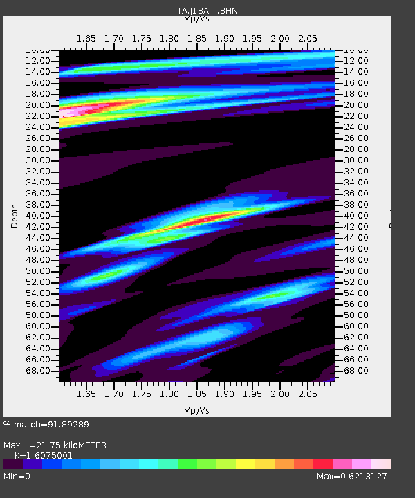
| Estimated Moho Depth: |
21.75 km |
| Estimated Crust Vp/Vs: |
1.61 |
| Assumed Crust Vp: |
6.207 km/s |
| Estimated Crust Vs: |
3.861 km/s |
| Estimated Crust Poisson's Ratio: |
0.18 |
|
| Radial Match: |
91.89289 % |
| Radial Bump: |
322 |
| Transverse Match: |
81.51398 % |
| Transverse Bump: |
400 |
| SOD ConfigId: |
2504 |
| Insert Time: |
2010-03-06 12:33:54.906 +0000 |
| GWidth: |
2.5 |
| Max Bumps: |
400 |
| Tol: |
0.001 |
|
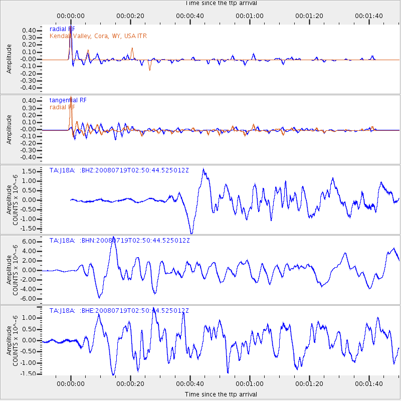
Signal To Noise
| Channel | StoN | STA | LTA |
| TA:J18A: :BHN:20080719T02:50:44.525012Z | 6.9155054 | 5.90812E-7 | 8.5432944E-8 |
| TA:J18A: :BHE:20080719T02:50:44.525012Z | 2.9054763 | 1.2231618E-7 | 4.2098495E-8 |
| TA:J18A: :BHZ:20080719T02:50:44.525012Z | 2.1248107 | 1.1649448E-7 | 5.482582E-8 |
| Arrivals |
| Ps | 2.2 SECOND |
| PpPs | 8.8 SECOND |
| PsPs/PpSs | 11 SECOND |


