You are here: Home > Network List > TA - USArray Transportable Network (new EarthScope stations) Stations List
> Station J18A Kendall Valley, Cora, WY, USA > Earthquake Result Viewer
J18A Kendall Valley, Cora, WY, USA - Earthquake Result Viewer

| Earthquake location: |
Eastern Honshu, Japan |
| Earthquake latitude/longitude: |
39.8/141.5 |
| Earthquake time(UTC): |
2008/07/23 (205) 15:26:19 GMT |
| Earthquake Depth: |
108 km |
| Earthquake Magnitude: |
6.6 MB, 6.8 MW, 6.8 MW |
| Earthquake Catalog/Contributor: |
WHDF/NEIC |
|
| Network: |
TA USArray Transportable Network (new EarthScope stations) |
| Station: |
J18A Kendall Valley, Cora, WY, USA |
| Lat/Lon: |
43.21 N/110.02 W |
| Elevation: |
2357 m |
|
| Distance: |
75.2 deg |
| Az: |
45.824 deg |
| Baz: |
310.913 deg |
| Ray Param: |
0.051597912 |
| Estimated Moho Depth: |
21.5 km |
| Estimated Crust Vp/Vs: |
1.60 |
| Assumed Crust Vp: |
6.207 km/s |
| Estimated Crust Vs: |
3.879 km/s |
| Estimated Crust Poisson's Ratio: |
0.18 |
|
| Radial Match: |
95.830154 % |
| Radial Bump: |
400 |
| Transverse Match: |
95.90784 % |
| Transverse Bump: |
400 |
| SOD ConfigId: |
2504 |
| Insert Time: |
2010-03-06 12:33:57.512 +0000 |
| GWidth: |
2.5 |
| Max Bumps: |
400 |
| Tol: |
0.001 |
|
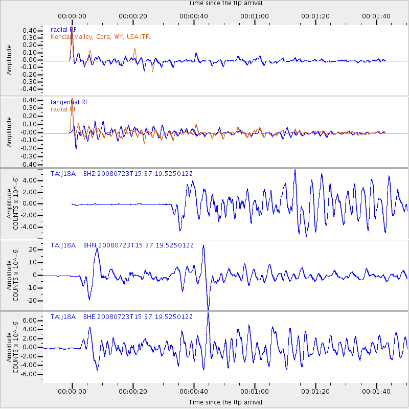
Signal To Noise
| Channel | StoN | STA | LTA |
| TA:J18A: :BHN:20080723T15:37:19.525012Z | 29.932507 | 2.9464593E-6 | 9.843677E-8 |
| TA:J18A: :BHE:20080723T15:37:19.525012Z | 10.418573 | 6.844383E-7 | 6.5694046E-8 |
| TA:J18A: :BHZ:20080723T15:37:19.525012Z | 11.602386 | 6.592333E-7 | 5.681877E-8 |
| Arrivals |
| Ps | 2.1 SECOND |
| PpPs | 8.7 SECOND |
| PsPs/PpSs | 11 SECOND |


