You are here: Home > Network List > CI - Caltech Regional Seismic Network Stations List
> Station MPP McPhearson Peak > Earthquake Result Viewer
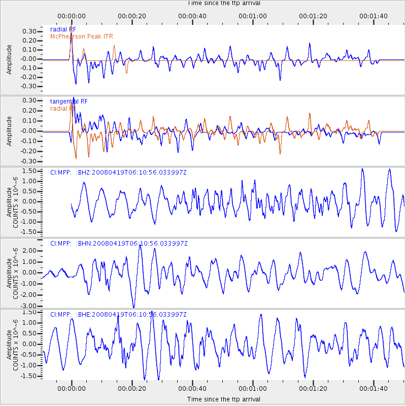
MPP McPhearson Peak - Earthquake Result Viewer
*The percent match for this event was below the threshold and hence no stack was calculated.
| Earthquake location: |
Loyalty Islands |
| Earthquake latitude/longitude: |
-20.3/168.8 |
| Earthquake time(UTC): |
2008/04/19 (110) 05:58:42 GMT |
| Earthquake Depth: |
14 km |
| Earthquake Magnitude: |
5.7 MB, 6.2 MS, 6.3 MW, 6.2 MW |
| Earthquake Catalog/Contributor: |
WHDF/NEIC |
|
| Network: |
CI Caltech Regional Seismic Network |
| Station: |
MPP McPhearson Peak |
| Lat/Lon: |
34.89 N/119.81 W |
| Elevation: |
1739 m |
|
| Distance: |
87.1 deg |
| Az: |
51.266 deg |
| Baz: |
242.979 deg |
| Ray Param: |
$rayparam |
*The percent match for this event was below the threshold and hence was not used in the summary stack. |
|
| Radial Match: |
63.327488 % |
| Radial Bump: |
337 |
| Transverse Match: |
61.110233 % |
| Transverse Bump: |
400 |
| SOD ConfigId: |
2504 |
| Insert Time: |
2010-02-26 02:04:35.663 +0000 |
| GWidth: |
2.5 |
| Max Bumps: |
400 |
| Tol: |
0.001 |
|
Signal To Noise
| Channel | StoN | STA | LTA |
| CI:MPP: :BHN:20080419T06:10:56.033997Z | 2.0704727 | 4.817067E-7 | 2.3265544E-7 |
| CI:MPP: :BHE:20080419T06:10:56.033997Z | 2.1610382 | 7.8042444E-7 | 3.6113403E-7 |
| CI:MPP: :BHZ:20080419T06:10:56.033997Z | 0.8781231 | 4.2523428E-7 | 4.842536E-7 |
| Arrivals |
| Ps | |
| PpPs | |
| PsPs/PpSs | |


