You are here: Home > Network List > TA - USArray Transportable Network (new EarthScope stations) Stations List
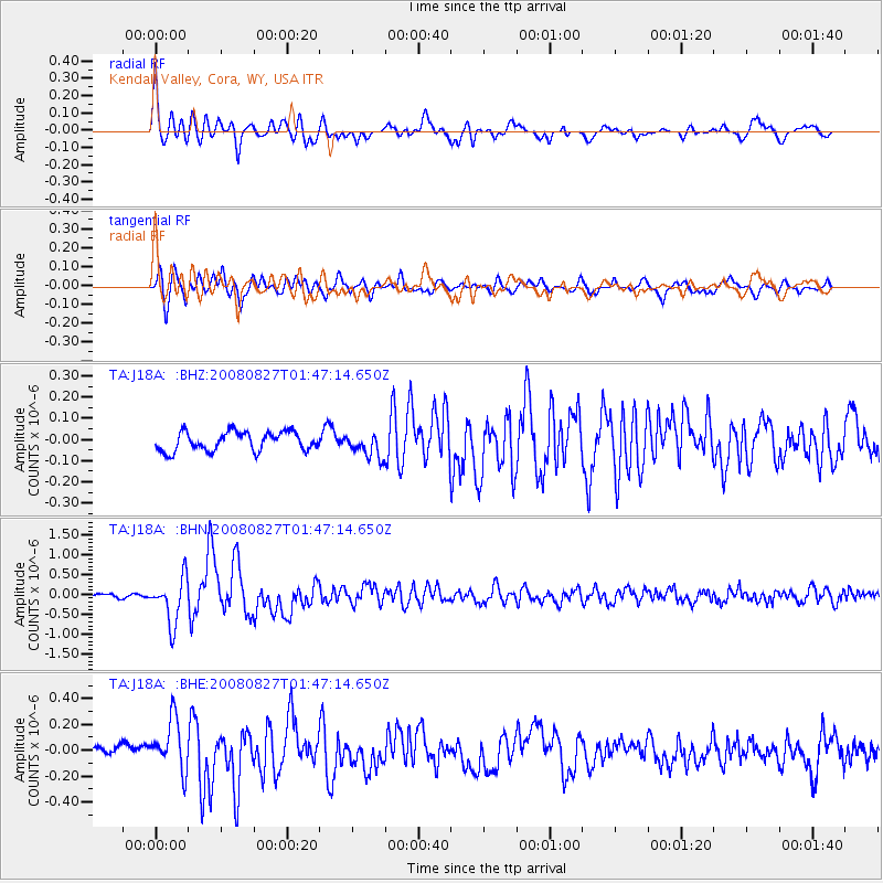
> Station J18A Kendall Valley, Cora, WY, USA > Earthquake Result Viewer
J18A Kendall Valley, Cora, WY, USA - Earthquake Result Viewer
| Earthquake location: |
Lake Baykal Region, Russia |
| Earthquake latitude/longitude: |
51.6/104.2 |
| Earthquake time(UTC): |
2008/08/27 (240) 01:35:32 GMT |
| Earthquake Depth: |
16 km |
| Earthquake Magnitude: |
5.8 MB, 6.2 MS, 6.2 MW, 6.2 MW |
| Earthquake Catalog/Contributor: |
WHDF/NEIC |
|
| Network: |
TA USArray Transportable Network (new EarthScope stations) |
| Station: |
J18A Kendall Valley, Cora, WY, USA |
| Lat/Lon: |
43.21 N/110.02 W |
| Elevation: |
2357 m |
|
| Distance: |
81.0 deg |
| Az: |
24.571 deg |
| Baz: |
339.227 deg |
| Ray Param: |
0.04787122 |
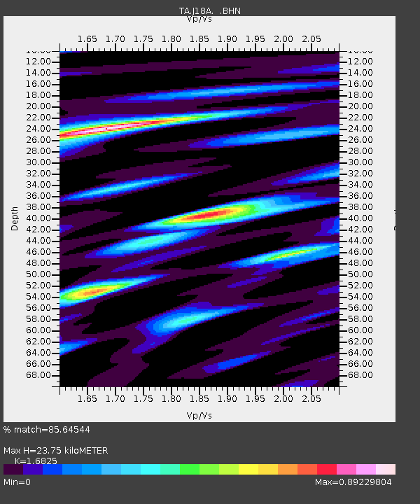
| Estimated Moho Depth: |
23.75 km |
| Estimated Crust Vp/Vs: |
1.68 |
| Assumed Crust Vp: |
6.207 km/s |
| Estimated Crust Vs: |
3.689 km/s |
| Estimated Crust Poisson's Ratio: |
0.23 |
|
| Radial Match: |
85.64544 % |
| Radial Bump: |
400 |
| Transverse Match: |
73.145996 % |
| Transverse Bump: |
400 |
| SOD ConfigId: |
2504 |
| Insert Time: |
2010-03-06 12:34:06.831 +0000 |
| GWidth: |
2.5 |
| Max Bumps: |
400 |
| Tol: |
0.001 |
|
Signal To Noise
| Channel | StoN | STA | LTA |
| TA:J18A: :BHN:20080827T01:47:14.650Z | 7.430979 | 5.766386E-7 | 7.759928E-8 |
| TA:J18A: :BHE:20080827T01:47:14.650Z | 3.0250797 | 2.0322965E-7 | 6.718158E-8 |
| TA:J18A: :BHZ:20080827T01:47:14.650Z | 1.30061 | 5.7797404E-8 | 4.4438693E-8 |
| Arrivals |
| Ps | 2.7 SECOND |
| PpPs | 10.0 SECOND |
| PsPs/PpSs | 13 SECOND |


