You are here: Home > Network List > TA - USArray Transportable Network (new EarthScope stations) Stations List
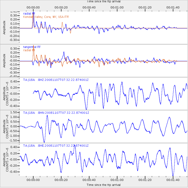
> Station J18A Kendall Valley, Cora, WY, USA > Earthquake Result Viewer
J18A Kendall Valley, Cora, WY, USA - Earthquake Result Viewer
| Earthquake location: |
Vanuatu Islands |
| Earthquake latitude/longitude: |
-14.8/168.0 |
| Earthquake time(UTC): |
2008/11/07 (312) 07:19:35 GMT |
| Earthquake Depth: |
13 km |
| Earthquake Magnitude: |
6.0 MB, 6.3 MS, 6.4 MW, 6.4 MW |
| Earthquake Catalog/Contributor: |
WHDF/NEIC |
|
| Network: |
TA USArray Transportable Network (new EarthScope stations) |
| Station: |
J18A Kendall Valley, Cora, WY, USA |
| Lat/Lon: |
43.21 N/110.02 W |
| Elevation: |
2357 m |
|
| Distance: |
94.3 deg |
| Az: |
46.547 deg |
| Baz: |
253.791 deg |
| Ray Param: |
0.041081034 |
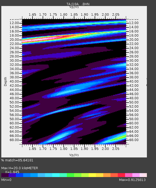
| Estimated Moho Depth: |
20.0 km |
| Estimated Crust Vp/Vs: |
1.64 |
| Assumed Crust Vp: |
6.207 km/s |
| Estimated Crust Vs: |
3.773 km/s |
| Estimated Crust Poisson's Ratio: |
0.21 |
|
| Radial Match: |
85.64181 % |
| Radial Bump: |
400 |
| Transverse Match: |
71.35058 % |
| Transverse Bump: |
400 |
| SOD ConfigId: |
2658 |
| Insert Time: |
2010-03-06 12:34:14.742 +0000 |
| GWidth: |
2.5 |
| Max Bumps: |
400 |
| Tol: |
0.001 |
|
Signal To Noise
| Channel | StoN | STA | LTA |
| TA:J18A: :BHN:20081107T07:32:22.874001Z | 2.7631104 | 2.5157595E-7 | 9.10481E-8 |
| TA:J18A: :BHE:20081107T07:32:22.874001Z | 0.9132606 | 8.797349E-8 | 9.632901E-8 |
| TA:J18A: :BHZ:20081107T07:32:22.874001Z | 1.7277572 | 1.355414E-7 | 7.844933E-8 |
| Arrivals |
| Ps | 2.1 SECOND |
| PpPs | 8.4 SECOND |
| PsPs/PpSs | 10 SECOND |


