You are here: Home > Network List > TA - USArray Transportable Network (new EarthScope stations) Stations List
> Station J18A Kendall Valley, Cora, WY, USA > Earthquake Result Viewer
J18A Kendall Valley, Cora, WY, USA - Earthquake Result Viewer

| Earthquake location: |
Chile-Bolivia Border Region |
| Earthquake latitude/longitude: |
-20.0/-69.0 |
| Earthquake time(UTC): |
2008/03/24 (084) 20:39:07 GMT |
| Earthquake Depth: |
120 km |
| Earthquake Magnitude: |
5.7 MB, 6.2 MW, 6.1 MW |
| Earthquake Catalog/Contributor: |
WHDF/NEIC |
|
| Network: |
TA USArray Transportable Network (new EarthScope stations) |
| Station: |
J18A Kendall Valley, Cora, WY, USA |
| Lat/Lon: |
43.21 N/110.02 W |
| Elevation: |
2357 m |
|
| Distance: |
73.4 deg |
| Az: |
329.926 deg |
| Baz: |
139.879 deg |
| Ray Param: |
0.05273898 |
| Estimated Moho Depth: |
46.0 km |
| Estimated Crust Vp/Vs: |
1.79 |
| Assumed Crust Vp: |
6.207 km/s |
| Estimated Crust Vs: |
3.477 km/s |
| Estimated Crust Poisson's Ratio: |
0.27 |
|
| Radial Match: |
81.8201 % |
| Radial Bump: |
400 |
| Transverse Match: |
60.878788 % |
| Transverse Bump: |
400 |
| SOD ConfigId: |
2564 |
| Insert Time: |
2010-03-06 12:34:20.787 +0000 |
| GWidth: |
2.5 |
| Max Bumps: |
400 |
| Tol: |
0.001 |
|
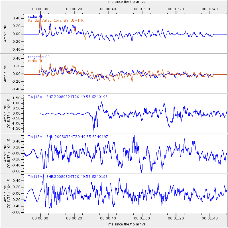
Signal To Noise
| Channel | StoN | STA | LTA |
| TA:J18A: :BHN:20080324T20:49:55.624019Z | 3.3189774 | 2.2539054E-7 | 6.790963E-8 |
| TA:J18A: :BHE:20080324T20:49:55.624019Z | 2.0712764 | 2.4549246E-7 | 1.1852231E-7 |
| TA:J18A: :BHZ:20080324T20:49:55.624019Z | 13.176327 | 7.067744E-7 | 5.3639717E-8 |
| Arrivals |
| Ps | 6.0 SECOND |
| PpPs | 20 SECOND |
| PsPs/PpSs | 26 SECOND |


