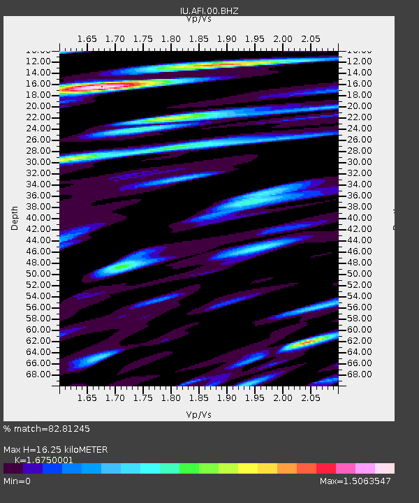
AFI Afiamalu, Samoa - Earthquake Result Viewer
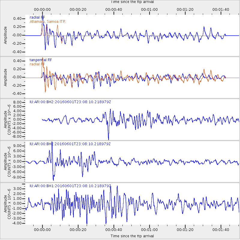
Earthquake location: Southern Sumatra, Indonesia
Earthquake latitude/longitude: -2.1/100.7
Earthquake time(UTC): 2016/06/01 (153) 22:56:00 GMT
Earthquake Depth: 50 km
Earthquake Magnitude: 6.6 MWW, 6.4 MWB, 6.6 MWC, 6.7 MWC
Earthquake Catalog/Contributor: NEIC PDE/NEIC COMCAT
Network: IU Global Seismograph Network (GSN - IRIS/USGS)
Station: AFI Afiamalu, Samoa
Lat/Lon: 13.91 S/171.78 W
Elevation: 706 m
Distance: 87.1 deg
Az: 103.74 deg
Baz: 268.566 deg
Ray Param: 0.043459833
Estimated Moho Depth: 16.25 km
Estimated Crust Vp/Vs: 1.68
Assumed Crust Vp: 4.24 km/s
Estimated Crust Vs: 2.531 km/s
Estimated Crust Poisson's Ratio: 0.22
Radial Match: 82.81245 %
Radial Bump: 400
Transverse Match: 63.87252 %
Transverse Bump: 400
SOD ConfigId: 1609551
Insert Time: 2016-06-22 14:47:00.944 +0000
GWidth: 2.5
Max Bumps: 400
Tol: 0.001

Signal To Noise

ChannelStoNSTALTA
IU:AFI:00:BHZ:20160601T23:08:10.218979Z6.0579581.9997005E-63.3009482E-7
IU:AFI:00:BH1:20160601T23:08:10.218979Z0.796120355.740938E-77.2111436E-7
IU:AFI:00:BH2:20160601T23:08:10.218979Z1.24551651.0083836E-68.0961075E-7
Arrivals
Ps2.6 SECOND
PpPs10 SECOND
PsPs/PpSs13 SECOND