You are here: Home > Network List > TA - USArray Transportable Network (new EarthScope stations) Stations List
> Station J18A Kendall Valley, Cora, WY, USA > Earthquake Result Viewer
J18A Kendall Valley, Cora, WY, USA - Earthquake Result Viewer
| Earthquake location: |
South Of Fiji Islands |
| Earthquake latitude/longitude: |
-26.0/-177.5 |
| Earthquake time(UTC): |
2007/12/09 (343) 07:28:20 GMT |
| Earthquake Depth: |
152 km |
| Earthquake Magnitude: |
7.0 MB, 7.8 MW, 7.7 MW |
| Earthquake Catalog/Contributor: |
WHDF/NEIC |
|
| Network: |
TA USArray Transportable Network (new EarthScope stations) |
| Station: |
J18A Kendall Valley, Cora, WY, USA |
| Lat/Lon: |
43.21 N/110.02 W |
| Elevation: |
2357 m |
|
| Distance: |
92.6 deg |
| Az: |
42.543 deg |
| Baz: |
236.336 deg |
| Ray Param: |
0.041336257 |
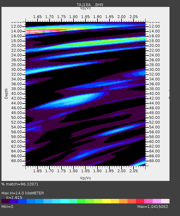
| Estimated Moho Depth: |
14.0 km |
| Estimated Crust Vp/Vs: |
1.62 |
| Assumed Crust Vp: |
6.207 km/s |
| Estimated Crust Vs: |
3.843 km/s |
| Estimated Crust Poisson's Ratio: |
0.19 |
|
| Radial Match: |
96.32871 % |
| Radial Bump: |
358 |
| Transverse Match: |
91.834274 % |
| Transverse Bump: |
400 |
| SOD ConfigId: |
2564 |
| Insert Time: |
2010-03-06 12:34:39.364 +0000 |
| GWidth: |
2.5 |
| Max Bumps: |
400 |
| Tol: |
0.001 |
|

Signal To Noise
| Channel | StoN | STA | LTA |
| TA:J18A: :BHN:20071209T07:40:43.799004Z | 1.4232427 | 1.7323252E-7 | 1.2171678E-7 |
| TA:J18A: :BHE:20071209T07:40:43.799004Z | 1.7115699 | 1.8899557E-7 | 1.1042235E-7 |
| TA:J18A: :BHZ:20071209T07:40:43.799004Z | 7.709845 | 1.0078611E-6 | 1.3072392E-7 |
| Arrivals |
| Ps | 1.4 SECOND |
| PpPs | 5.8 SECOND |
| PsPs/PpSs | 7.2 SECOND |


