You are here: Home > Network List > IU - Global Seismograph Network (GSN - IRIS/USGS) Stations List
> Station JOHN Johnston Island, USA > Earthquake Result Viewer
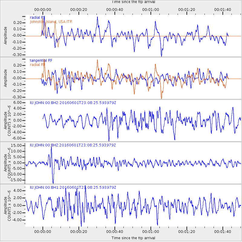
JOHN Johnston Island, USA - Earthquake Result Viewer
*The percent match for this event was below the threshold and hence no stack was calculated.
| Earthquake location: |
Southern Sumatra, Indonesia |
| Earthquake latitude/longitude: |
-2.1/100.7 |
| Earthquake time(UTC): |
2016/06/01 (153) 22:56:00 GMT |
| Earthquake Depth: |
50 km |
| Earthquake Magnitude: |
6.6 MWW, 6.4 MWB, 6.6 MWC, 6.7 MWC |
| Earthquake Catalog/Contributor: |
NEIC PDE/NEIC COMCAT |
|
| Network: |
IU Global Seismograph Network (GSN - IRIS/USGS) |
| Station: |
JOHN Johnston Island, USA |
| Lat/Lon: |
16.73 N/169.53 W |
| Elevation: |
2.0 m |
|
| Distance: |
90.4 deg |
| Az: |
73.377 deg |
| Baz: |
267.955 deg |
| Ray Param: |
$rayparam |
*The percent match for this event was below the threshold and hence was not used in the summary stack. |
|
| Radial Match: |
63.531967 % |
| Radial Bump: |
400 |
| Transverse Match: |
59.470036 % |
| Transverse Bump: |
400 |
| SOD ConfigId: |
1609551 |
| Insert Time: |
2016-06-22 14:47:23.982 +0000 |
| GWidth: |
2.5 |
| Max Bumps: |
400 |
| Tol: |
0.001 |
|
Signal To Noise
| Channel | StoN | STA | LTA |
| IU:JOHN:00:BHZ:20160601T23:08:25.593979Z | 3.32736 | 4.0234922E-6 | 1.2092147E-6 |
| IU:JOHN:00:BH1:20160601T23:08:25.593979Z | 1.7626885 | 1.8468196E-6 | 1.0477288E-6 |
| IU:JOHN:00:BH2:20160601T23:08:25.593979Z | 1.0670744 | 1.3976279E-6 | 1.3097755E-6 |
| Arrivals |
| Ps | |
| PpPs | |
| PsPs/PpSs | |


