You are here: Home > Network List > TA - USArray Transportable Network (new EarthScope stations) Stations List
> Station J18A Kendall Valley, Cora, WY, USA > Earthquake Result Viewer
J18A Kendall Valley, Cora, WY, USA - Earthquake Result Viewer
| Earthquake location: |
Andreanof Islands, Aleutian Is. |
| Earthquake latitude/longitude: |
51.9/-179.2 |
| Earthquake time(UTC): |
2008/04/16 (107) 05:54:19 GMT |
| Earthquake Depth: |
13 km |
| Earthquake Magnitude: |
6.1 MB, 6.5 MS, 6.6 MW, 6.6 MW |
| Earthquake Catalog/Contributor: |
WHDF/NEIC |
|
| Network: |
TA USArray Transportable Network (new EarthScope stations) |
| Station: |
J18A Kendall Valley, Cora, WY, USA |
| Lat/Lon: |
43.21 N/110.02 W |
| Elevation: |
2357 m |
|
| Distance: |
45.8 deg |
| Az: |
72.251 deg |
| Baz: |
306.146 deg |
| Ray Param: |
0.0710086 |
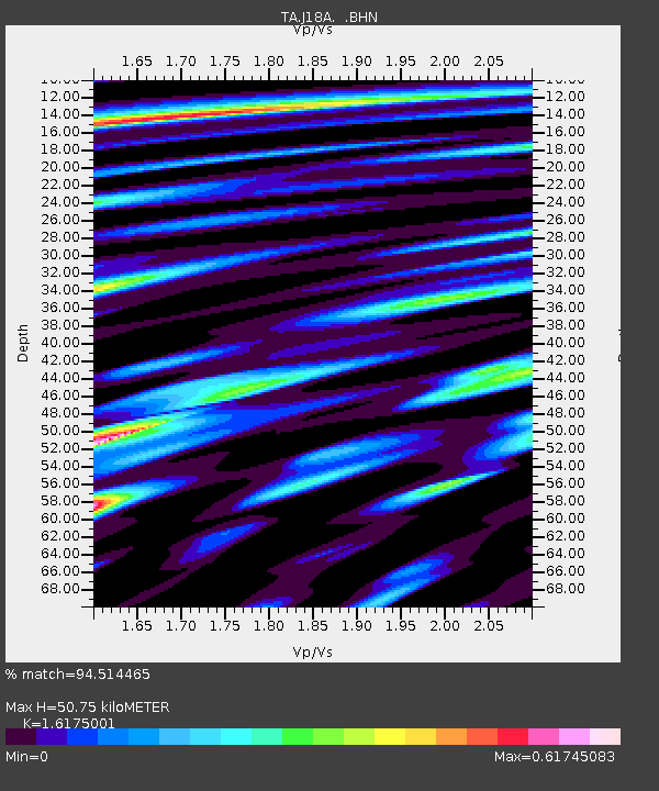
| Estimated Moho Depth: |
50.75 km |
| Estimated Crust Vp/Vs: |
1.62 |
| Assumed Crust Vp: |
6.207 km/s |
| Estimated Crust Vs: |
3.837 km/s |
| Estimated Crust Poisson's Ratio: |
0.19 |
|
| Radial Match: |
94.514465 % |
| Radial Bump: |
400 |
| Transverse Match: |
73.64374 % |
| Transverse Bump: |
400 |
| SOD ConfigId: |
2504 |
| Insert Time: |
2010-03-06 12:34:59.824 +0000 |
| GWidth: |
2.5 |
| Max Bumps: |
400 |
| Tol: |
0.001 |
|

Signal To Noise
| Channel | StoN | STA | LTA |
| TA:J18A: :BHN:20080416T06:02:10.424009Z | 6.3789153 | 5.3076155E-7 | 8.320561E-8 |
| TA:J18A: :BHE:20080416T06:02:10.424009Z | 1.4007124 | 2.3421846E-7 | 1.6721381E-7 |
| TA:J18A: :BHZ:20080416T06:02:10.424009Z | 0.7685037 | 1.3514925E-7 | 1.7586024E-7 |
| Arrivals |
| Ps | 5.4 SECOND |
| PpPs | 20 SECOND |
| PsPs/PpSs | 25 SECOND |


