You are here: Home > Network List > CI - Caltech Regional Seismic Network Stations List
> Station MPP McPhearson Peak > Earthquake Result Viewer
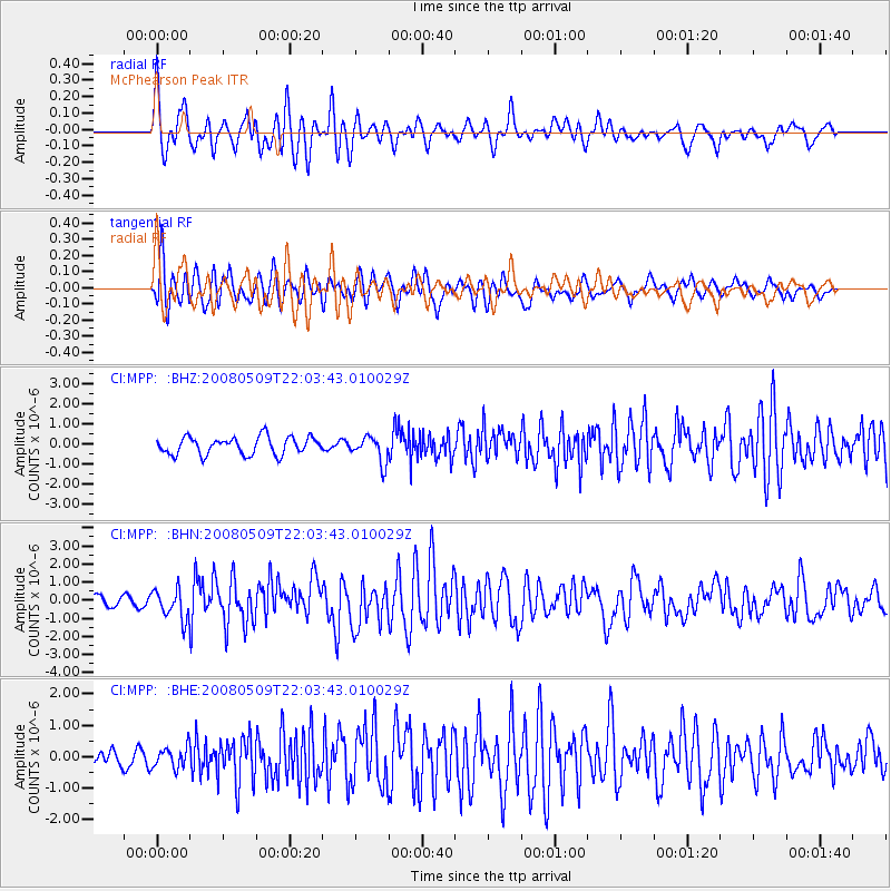
MPP McPhearson Peak - Earthquake Result Viewer
*The percent match for this event was below the threshold and hence no stack was calculated.
| Earthquake location: |
South Of Mariana Islands |
| Earthquake latitude/longitude: |
12.5/143.2 |
| Earthquake time(UTC): |
2008/05/09 (130) 21:51:29 GMT |
| Earthquake Depth: |
76 km |
| Earthquake Magnitude: |
6.1 MB, 6.7 MW, 6.7 MW |
| Earthquake Catalog/Contributor: |
WHDF/NEIC |
|
| Network: |
CI Caltech Regional Seismic Network |
| Station: |
MPP McPhearson Peak |
| Lat/Lon: |
34.89 N/119.81 W |
| Elevation: |
1739 m |
|
| Distance: |
88.6 deg |
| Az: |
54.704 deg |
| Baz: |
284.176 deg |
| Ray Param: |
$rayparam |
*The percent match for this event was below the threshold and hence was not used in the summary stack. |
|
| Radial Match: |
80.06142 % |
| Radial Bump: |
400 |
| Transverse Match: |
77.746254 % |
| Transverse Bump: |
400 |
| SOD ConfigId: |
2504 |
| Insert Time: |
2010-02-26 02:04:38.597 +0000 |
| GWidth: |
2.5 |
| Max Bumps: |
400 |
| Tol: |
0.001 |
|
Signal To Noise
| Channel | StoN | STA | LTA |
| CI:MPP: :BHN:20080509T22:03:43.010029Z | 2.5794916 | 8.225193E-7 | 3.1886879E-7 |
| CI:MPP: :BHE:20080509T22:03:43.010029Z | 1.2912215 | 3.3168493E-7 | 2.5687686E-7 |
| CI:MPP: :BHZ:20080509T22:03:43.010029Z | 1.465194 | 6.377545E-7 | 4.3526967E-7 |
| Arrivals |
| Ps | |
| PpPs | |
| PsPs/PpSs | |


