You are here: Home > Network List > UW - Pacific Northwest Regional Seismic Network Stations List
> Station LEBA Lebam, WA, USA > Earthquake Result Viewer
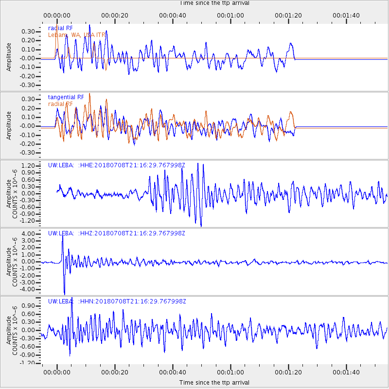
LEBA Lebam, WA, USA - Earthquake Result Viewer
*The percent match for this event was below the threshold and hence no stack was calculated.
| Earthquake location: |
Vanuatu Islands |
| Earthquake latitude/longitude: |
-19.0/169.5 |
| Earthquake time(UTC): |
2018/07/08 (189) 21:04:36 GMT |
| Earthquake Depth: |
259 km |
| Earthquake Magnitude: |
5.5 Mww |
| Earthquake Catalog/Contributor: |
NEIC PDE/us |
|
| Network: |
UW Pacific Northwest Regional Seismic Network |
| Station: |
LEBA Lebam, WA, USA |
| Lat/Lon: |
46.55 N/123.56 W |
| Elevation: |
73 m |
|
| Distance: |
88.8 deg |
| Az: |
39.431 deg |
| Baz: |
240.517 deg |
| Ray Param: |
$rayparam |
*The percent match for this event was below the threshold and hence was not used in the summary stack. |
|
| Radial Match: |
75.5563 % |
| Radial Bump: |
400 |
| Transverse Match: |
62.123886 % |
| Transverse Bump: |
400 |
| SOD ConfigId: |
13570011 |
| Insert Time: |
2019-04-30 13:22:41.161 +0000 |
| GWidth: |
2.5 |
| Max Bumps: |
400 |
| Tol: |
0.001 |
|
Signal To Noise
| Channel | StoN | STA | LTA |
| UW:LEBA: :HHZ:20180708T21:16:29.767998Z | 14.42883 | 1.5826574E-6 | 1.09687164E-7 |
| UW:LEBA: :HHN:20180708T21:16:29.767998Z | 3.5067239 | 3.1041426E-7 | 8.8519734E-8 |
| UW:LEBA: :HHE:20180708T21:16:29.767998Z | 3.0877204 | 3.4142474E-7 | 1.1057502E-7 |
| Arrivals |
| Ps | |
| PpPs | |
| PsPs/PpSs | |


