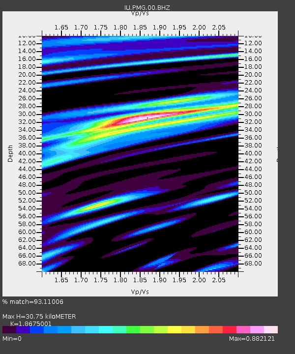
PMG Port Moresby, New Guinea - Earthquake Result Viewer

Earthquake location: Southern Sumatra, Indonesia
Earthquake latitude/longitude: -2.1/100.7
Earthquake time(UTC): 2016/06/01 (153) 22:56:00 GMT
Earthquake Depth: 50 km
Earthquake Magnitude: 6.6 MWW, 6.4 MWB, 6.6 MWC, 6.7 MWC
Earthquake Catalog/Contributor: NEIC PDE/NEIC COMCAT
Network: IU Global Seismograph Network (GSN - IRIS/USGS)
Station: PMG Port Moresby, New Guinea
Lat/Lon: 9.40 S/147.16 E
Elevation: 90 m
Distance: 46.8 deg
Az: 100.886 deg
Baz: 275.982 deg
Ray Param: 0.070287615
Estimated Moho Depth: 30.75 km
Estimated Crust Vp/Vs: 1.87
Assumed Crust Vp: 6.122 km/s
Estimated Crust Vs: 3.278 km/s
Estimated Crust Poisson's Ratio: 0.30
Radial Match: 93.11006 %
Radial Bump: 400
Transverse Match: 78.14323 %
Transverse Bump: 400
SOD ConfigId: 1609551
Insert Time: 2016-06-22 14:47:55.002 +0000
GWidth: 2.5
Max Bumps: 400
Tol: 0.001

Signal To Noise

ChannelStoNSTALTA
IU:PMG:00:BHZ:20160601T23:03:54.869004Z19.6115535.517894E-62.8135935E-7
IU:PMG:00:BH1:20160601T23:03:54.869004Z2.67229776.174114E-72.3104138E-7
IU:PMG:00:BH2:20160601T23:03:54.869004Z9.3984682.5439322E-62.706752E-7
Arrivals
Ps4.6 SECOND
PpPs14 SECOND
PsPs/PpSs18 SECOND