You are here: Home > Network List > CI - Caltech Regional Seismic Network Stations List
> Station MPP McPhearson Peak > Earthquake Result Viewer
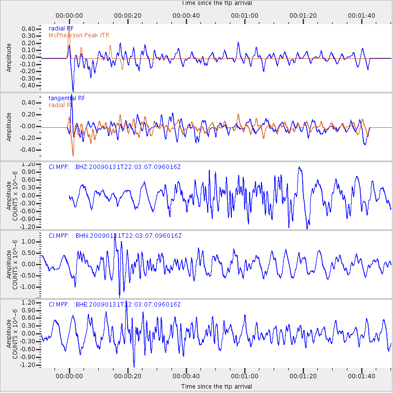
MPP McPhearson Peak - Earthquake Result Viewer
*The percent match for this event was below the threshold and hence no stack was calculated.
| Earthquake location: |
Near East Coast Of Honshu, Japan |
| Earthquake latitude/longitude: |
36.7/141.1 |
| Earthquake time(UTC): |
2009/01/31 (031) 21:51:52 GMT |
| Earthquake Depth: |
34 km |
| Earthquake Magnitude: |
5.6 MB, 5.3 MS, 5.8 MW, 5.7 MW |
| Earthquake Catalog/Contributor: |
WHDF/NEIC |
|
| Network: |
CI Caltech Regional Seismic Network |
| Station: |
MPP McPhearson Peak |
| Lat/Lon: |
34.89 N/119.81 W |
| Elevation: |
1739 m |
|
| Distance: |
76.4 deg |
| Az: |
56.646 deg |
| Baz: |
305.272 deg |
| Ray Param: |
$rayparam |
*The percent match for this event was below the threshold and hence was not used in the summary stack. |
|
| Radial Match: |
66.35748 % |
| Radial Bump: |
400 |
| Transverse Match: |
54.60121 % |
| Transverse Bump: |
399 |
| SOD ConfigId: |
2658 |
| Insert Time: |
2010-02-26 02:04:39.863 +0000 |
| GWidth: |
2.5 |
| Max Bumps: |
400 |
| Tol: |
0.001 |
|
Signal To Noise
| Channel | StoN | STA | LTA |
| CI:MPP: :BHN:20090131T22:03:07.096016Z | 2.1942928 | 4.4981687E-7 | 2.04994E-7 |
| CI:MPP: :BHE:20090131T22:03:07.096016Z | 2.4332926 | 4.5940135E-7 | 1.8879824E-7 |
| CI:MPP: :BHZ:20090131T22:03:07.096016Z | 1.3713636 | 3.181481E-7 | 2.3199397E-7 |
| Arrivals |
| Ps | |
| PpPs | |
| PsPs/PpSs | |


