You are here: Home > Network List > TJ - Tajikistan National Seismic Network Stations List
> Station CHGR Chuyangaron, Tajikistan > Earthquake Result Viewer
CHGR Chuyangaron, Tajikistan - Earthquake Result Viewer
| Earthquake location: |
Southwest Indian Ridge |
| Earthquake latitude/longitude: |
-31.6/58.3 |
| Earthquake time(UTC): |
2018/07/10 (191) 10:26:21 GMT |
| Earthquake Depth: |
10 km |
| Earthquake Magnitude: |
5.6 Mww |
| Earthquake Catalog/Contributor: |
NEIC PDE/us |
|
| Network: |
TJ Tajikistan National Seismic Network |
| Station: |
CHGR Chuyangaron, Tajikistan |
| Lat/Lon: |
38.66 N/69.16 E |
| Elevation: |
1049 m |
|
| Distance: |
70.6 deg |
| Az: |
8.955 deg |
| Baz: |
189.767 deg |
| Ray Param: |
0.054866288 |
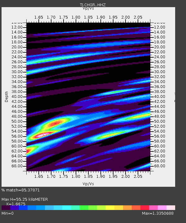
| Estimated Moho Depth: |
55.25 km |
| Estimated Crust Vp/Vs: |
1.67 |
| Assumed Crust Vp: |
6.483 km/s |
| Estimated Crust Vs: |
3.888 km/s |
| Estimated Crust Poisson's Ratio: |
0.22 |
|
| Radial Match: |
85.37871 % |
| Radial Bump: |
400 |
| Transverse Match: |
75.80522 % |
| Transverse Bump: |
400 |
| SOD ConfigId: |
13570011 |
| Insert Time: |
2019-04-30 13:26:21.670 +0000 |
| GWidth: |
2.5 |
| Max Bumps: |
400 |
| Tol: |
0.001 |
|

Signal To Noise
| Channel | StoN | STA | LTA |
| TJ:CHGR: :HHZ:20180710T10:37:06.159993Z | 5.438247 | 8.5806926E-7 | 1.5778414E-7 |
| TJ:CHGR: :HHN:20180710T10:37:06.159993Z | 4.6597877 | 4.450507E-7 | 9.5508796E-8 |
| TJ:CHGR: :HHE:20180710T10:37:06.159993Z | 1.2023711 | 1.340163E-7 | 1.11460004E-7 |
| Arrivals |
| Ps | 5.9 SECOND |
| PpPs | 22 SECOND |
| PsPs/PpSs | 28 SECOND |


