You are here: Home > Network List > TA - USArray Transportable Network (new EarthScope stations) Stations List
> Station J18A Kendall Valley, Cora, WY, USA > Earthquake Result Viewer
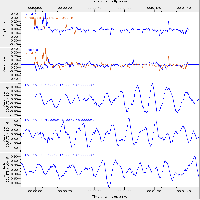
J18A Kendall Valley, Cora, WY, USA - Earthquake Result Viewer
*The percent match for this event was below the threshold and hence no stack was calculated.
| Earthquake location: |
Tonga Islands |
| Earthquake latitude/longitude: |
-18.6/-175.7 |
| Earthquake time(UTC): |
2008/04/16 (107) 00:35:48 GMT |
| Earthquake Depth: |
10 km |
| Earthquake Magnitude: |
5.6 MB, 6.3 MS, 6.3 MW, 6.3 MW |
| Earthquake Catalog/Contributor: |
WHDF/NEIC |
|
| Network: |
TA USArray Transportable Network (new EarthScope stations) |
| Station: |
J18A Kendall Valley, Cora, WY, USA |
| Lat/Lon: |
43.21 N/110.02 W |
| Elevation: |
2357 m |
|
| Distance: |
86.0 deg |
| Az: |
41.9 deg |
| Baz: |
240.028 deg |
| Ray Param: |
$rayparam |
*The percent match for this event was below the threshold and hence was not used in the summary stack. |
|
| Radial Match: |
81.76853 % |
| Radial Bump: |
390 |
| Transverse Match: |
43.775032 % |
| Transverse Bump: |
400 |
| SOD ConfigId: |
2504 |
| Insert Time: |
2010-03-06 12:36:16.275 +0000 |
| GWidth: |
2.5 |
| Max Bumps: |
400 |
| Tol: |
0.001 |
|
Signal To Noise
| Channel | StoN | STA | LTA |
| TA:J18A: :BHN:20080416T00:47:58.000005Z | 0.35015464 | 2.0114639E-7 | 5.7445015E-7 |
| TA:J18A: :BHE:20080416T00:47:58.000005Z | 1.3248355 | 3.7762118E-7 | 2.8503248E-7 |
| TA:J18A: :BHZ:20080416T00:47:58.000005Z | 0.27592713 | 8.9222496E-8 | 3.233553E-7 |
| Arrivals |
| Ps | |
| PpPs | |
| PsPs/PpSs | |


