You are here: Home > Network List > KZ - Kazakhstan Network Stations List
> Station ABKAR Akbulak array,AB31, Kazakhstan > Earthquake Result Viewer
ABKAR Akbulak array,AB31, Kazakhstan - Earthquake Result Viewer
| Earthquake location: |
Southwest Indian Ridge |
| Earthquake latitude/longitude: |
-31.6/58.2 |
| Earthquake time(UTC): |
2018/07/10 (191) 16:05:09 GMT |
| Earthquake Depth: |
10 km |
| Earthquake Magnitude: |
5.6 Mww |
| Earthquake Catalog/Contributor: |
NEIC PDE/us |
|
| Network: |
KZ Kazakhstan Network |
| Station: |
ABKAR Akbulak array,AB31, Kazakhstan |
| Lat/Lon: |
49.26 N/59.94 E |
| Elevation: |
362 m |
|
| Distance: |
80.5 deg |
| Az: |
1.189 deg |
| Baz: |
181.548 deg |
| Ray Param: |
0.048221383 |
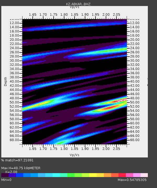
| Estimated Moho Depth: |
48.75 km |
| Estimated Crust Vp/Vs: |
2.08 |
| Assumed Crust Vp: |
6.35 km/s |
| Estimated Crust Vs: |
3.053 km/s |
| Estimated Crust Poisson's Ratio: |
0.35 |
|
| Radial Match: |
97.21891 % |
| Radial Bump: |
376 |
| Transverse Match: |
92.2527 % |
| Transverse Bump: |
400 |
| SOD ConfigId: |
13570011 |
| Insert Time: |
2019-04-30 13:28:23.709 +0000 |
| GWidth: |
2.5 |
| Max Bumps: |
400 |
| Tol: |
0.001 |
|

Signal To Noise
| Channel | StoN | STA | LTA |
| KZ:ABKAR: :BHZ:20180710T16:16:50.526021Z | 21.24874 | 1.4694094E-6 | 6.915278E-8 |
| KZ:ABKAR: :BHN:20180710T16:16:50.526021Z | 17.089172 | 6.24306E-7 | 3.6532253E-8 |
| KZ:ABKAR: :BHE:20180710T16:16:50.526021Z | 4.966763 | 2.6475465E-7 | 5.330527E-8 |
| Arrivals |
| Ps | 8.5 SECOND |
| PpPs | 23 SECOND |
| PsPs/PpSs | 32 SECOND |


