You are here: Home > Network List > TA - USArray Transportable Network (new EarthScope stations) Stations List
> Station J18A Kendall Valley, Cora, WY, USA > Earthquake Result Viewer
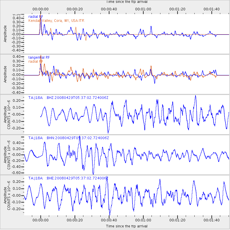
J18A Kendall Valley, Cora, WY, USA - Earthquake Result Viewer
*The percent match for this event was below the threshold and hence no stack was calculated.
| Earthquake location: |
Hokkaido, Japan Region |
| Earthquake latitude/longitude: |
41.5/142.0 |
| Earthquake time(UTC): |
2008/04/29 (120) 05:26:04 GMT |
| Earthquake Depth: |
47 km |
| Earthquake Magnitude: |
5.5 MB, 5.2 MS, 5.8 MW, 5.8 MW |
| Earthquake Catalog/Contributor: |
WHDF/NEIC |
|
| Network: |
TA USArray Transportable Network (new EarthScope stations) |
| Station: |
J18A Kendall Valley, Cora, WY, USA |
| Lat/Lon: |
43.21 N/110.02 W |
| Elevation: |
2357 m |
|
| Distance: |
73.7 deg |
| Az: |
46.439 deg |
| Baz: |
311.837 deg |
| Ray Param: |
$rayparam |
*The percent match for this event was below the threshold and hence was not used in the summary stack. |
|
| Radial Match: |
70.75252 % |
| Radial Bump: |
400 |
| Transverse Match: |
71.08437 % |
| Transverse Bump: |
400 |
| SOD ConfigId: |
2504 |
| Insert Time: |
2010-03-06 12:36:23.933 +0000 |
| GWidth: |
2.5 |
| Max Bumps: |
400 |
| Tol: |
0.001 |
|
Signal To Noise
| Channel | StoN | STA | LTA |
| TA:J18A: :BHN:20080429T05:37:02.724006Z | 1.9602106 | 2.332472E-7 | 1.1899089E-7 |
| TA:J18A: :BHE:20080429T05:37:02.724006Z | 1.6062566 | 1.0996051E-7 | 6.8457624E-8 |
| TA:J18A: :BHZ:20080429T05:37:02.724006Z | 1.3839456 | 8.760345E-8 | 6.329979E-8 |
| Arrivals |
| Ps | |
| PpPs | |
| PsPs/PpSs | |


