You are here: Home > Network List > TJ - Tajikistan National Seismic Network Stations List
> Station GARM Garm, Tajikistan > Earthquake Result Viewer
GARM Garm, Tajikistan - Earthquake Result Viewer
*The percent match for this event was below the threshold and hence no stack was calculated.
| Earthquake location: |
Southwest Indian Ridge |
| Earthquake latitude/longitude: |
-31.6/58.2 |
| Earthquake time(UTC): |
2018/07/10 (191) 16:05:09 GMT |
| Earthquake Depth: |
10 km |
| Earthquake Magnitude: |
5.6 Mww |
| Earthquake Catalog/Contributor: |
NEIC PDE/us |
|
| Network: |
TJ Tajikistan National Seismic Network |
| Station: |
GARM Garm, Tajikistan |
| Lat/Lon: |
39.00 N/70.32 E |
| Elevation: |
1305 m |
|
| Distance: |
71.2 deg |
| Az: |
9.989 deg |
| Baz: |
190.949 deg |
| Ray Param: |
$rayparam |
*The percent match for this event was below the threshold and hence was not used in the summary stack. |
|
| Radial Match: |
57.83809 % |
| Radial Bump: |
400 |
| Transverse Match: |
69.96627 % |
| Transverse Bump: |
400 |
| SOD ConfigId: |
13570011 |
| Insert Time: |
2019-04-30 13:29:06.914 +0000 |
| GWidth: |
2.5 |
| Max Bumps: |
400 |
| Tol: |
0.001 |
|
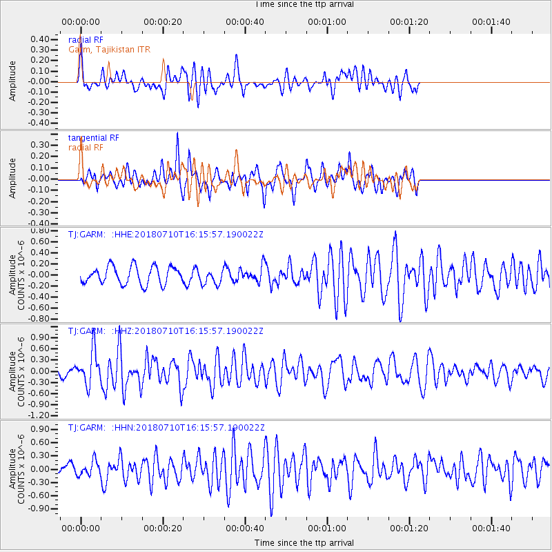
Signal To Noise
| Channel | StoN | STA | LTA |
| TJ:GARM: :HHZ:20180710T16:15:57.190022Z | 6.2182865 | 4.6222675E-7 | 7.433346E-8 |
| TJ:GARM: :HHN:20180710T16:15:57.190022Z | 1.7842262 | 1.6653887E-7 | 9.333955E-8 |
| TJ:GARM: :HHE:20180710T16:15:57.190022Z | 0.86717457 | 1.3757497E-7 | 1.5864737E-7 |
| Arrivals |
| Ps | |
| PpPs | |
| PsPs/PpSs | |


