You are here: Home > Network List > TJ - Tajikistan National Seismic Network Stations List
> Station CHGR Chuyangaron, Tajikistan > Earthquake Result Viewer
CHGR Chuyangaron, Tajikistan - Earthquake Result Viewer
| Earthquake location: |
Southwest Indian Ridge |
| Earthquake latitude/longitude: |
-31.6/58.2 |
| Earthquake time(UTC): |
2018/07/10 (191) 16:05:09 GMT |
| Earthquake Depth: |
10 km |
| Earthquake Magnitude: |
5.6 Mww |
| Earthquake Catalog/Contributor: |
NEIC PDE/us |
|
| Network: |
TJ Tajikistan National Seismic Network |
| Station: |
CHGR Chuyangaron, Tajikistan |
| Lat/Lon: |
38.66 N/69.16 E |
| Elevation: |
1049 m |
|
| Distance: |
70.7 deg |
| Az: |
9.114 deg |
| Baz: |
189.94 deg |
| Ray Param: |
0.05483966 |
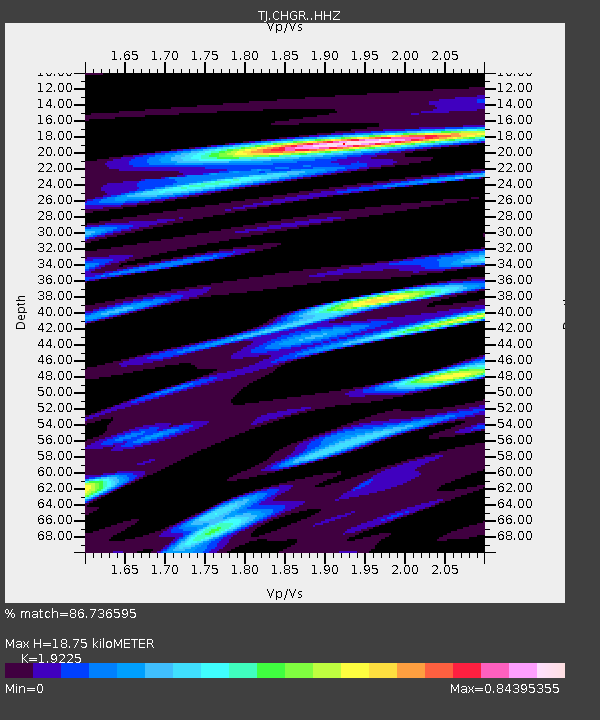
| Estimated Moho Depth: |
18.75 km |
| Estimated Crust Vp/Vs: |
1.92 |
| Assumed Crust Vp: |
6.483 km/s |
| Estimated Crust Vs: |
3.372 km/s |
| Estimated Crust Poisson's Ratio: |
0.31 |
|
| Radial Match: |
86.736595 % |
| Radial Bump: |
400 |
| Transverse Match: |
79.42374 % |
| Transverse Bump: |
400 |
| SOD ConfigId: |
13570011 |
| Insert Time: |
2019-04-30 13:29:06.971 +0000 |
| GWidth: |
2.5 |
| Max Bumps: |
400 |
| Tol: |
0.001 |
|

Signal To Noise
| Channel | StoN | STA | LTA |
| TJ:CHGR: :HHZ:20180710T16:15:54.159993Z | 11.161182 | 1.3013945E-6 | 1.16600056E-7 |
| TJ:CHGR: :HHN:20180710T16:15:54.159993Z | 3.9273415 | 5.603805E-7 | 1.4268699E-7 |
| TJ:CHGR: :HHE:20180710T16:15:54.159993Z | 2.4073203 | 1.9677569E-7 | 8.174055E-8 |
| Arrivals |
| Ps | 2.8 SECOND |
| PpPs | 8.2 SECOND |
| PsPs/PpSs | 11 SECOND |


