You are here: Home > Network List > TJ - Tajikistan National Seismic Network Stations List
> Station CHRDR Chorukh Dayron, Tajikistan > Earthquake Result Viewer
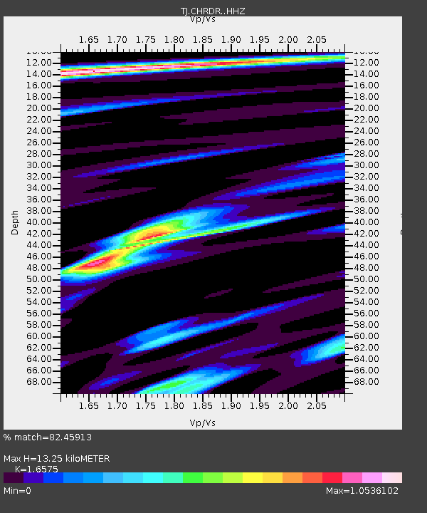
CHRDR Chorukh Dayron, Tajikistan - Earthquake Result Viewer
| Earthquake location: |
Southwest Indian Ridge |
| Earthquake latitude/longitude: |
-31.6/58.2 |
| Earthquake time(UTC): |
2018/07/10 (191) 16:05:09 GMT |
| Earthquake Depth: |
10 km |
| Earthquake Magnitude: |
5.6 Mww |
| Earthquake Catalog/Contributor: |
NEIC PDE/us |
|
| Network: |
TJ Tajikistan National Seismic Network |
| Station: |
CHRDR Chorukh Dayron, Tajikistan |
| Lat/Lon: |
40.39 N/69.67 E |
| Elevation: |
580 m |
|
| Distance: |
72.4 deg |
| Az: |
9.206 deg |
| Baz: |
190.294 deg |
| Ray Param: |
0.053668868 |
| Estimated Moho Depth: |
13.25 km |
| Estimated Crust Vp/Vs: |
1.66 |
| Assumed Crust Vp: |
6.316 km/s |
| Estimated Crust Vs: |
3.81 km/s |
| Estimated Crust Poisson's Ratio: |
0.21 |
|
| Radial Match: |
82.45913 % |
| Radial Bump: |
400 |
| Transverse Match: |
70.19243 % |
| Transverse Bump: |
400 |
| SOD ConfigId: |
13570011 |
| Insert Time: |
2019-04-30 13:29:05.600 +0000 |
| GWidth: |
2.5 |
| Max Bumps: |
400 |
| Tol: |
0.001 |
|

Signal To Noise
| Channel | StoN | STA | LTA |
| TJ:CHRDR: :HHZ:20180710T16:16:04.800007Z | 8.429741 | 8.8697254E-7 | 1.0521942E-7 |
| TJ:CHRDR: :HHN:20180710T16:16:04.800007Z | 2.163557 | 1.9105575E-7 | 8.830632E-8 |
| TJ:CHRDR: :HHE:20180710T16:16:04.800007Z | 1.29208 | 8.3588624E-8 | 6.469307E-8 |
| Arrivals |
| Ps | 1.4 SECOND |
| PpPs | 5.4 SECOND |
| PsPs/PpSs | 6.8 SECOND |


