You are here: Home > Network List > TA - USArray Transportable Network (new EarthScope stations) Stations List
> Station R32K Eaglecrest, AK, USA > Earthquake Result Viewer
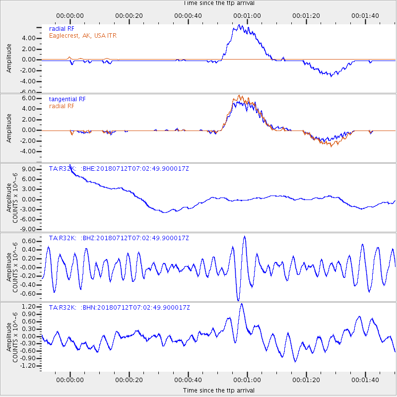
R32K Eaglecrest, AK, USA - Earthquake Result Viewer
*The percent match for this event was below the threshold and hence no stack was calculated.
| Earthquake location: |
South Of Fiji Islands |
| Earthquake latitude/longitude: |
-23.3/-179.9 |
| Earthquake time(UTC): |
2018/07/12 (193) 06:51:21 GMT |
| Earthquake Depth: |
540 km |
| Earthquake Magnitude: |
5.5 Mww |
| Earthquake Catalog/Contributor: |
NEIC PDE/us |
|
| Network: |
TA USArray Transportable Network (new EarthScope stations) |
| Station: |
R32K Eaglecrest, AK, USA |
| Lat/Lon: |
58.27 N/134.52 W |
| Elevation: |
386 m |
|
| Distance: |
89.6 deg |
| Az: |
22.097 deg |
| Baz: |
220.866 deg |
| Ray Param: |
$rayparam |
*The percent match for this event was below the threshold and hence was not used in the summary stack. |
|
| Radial Match: |
38.932903 % |
| Radial Bump: |
400 |
| Transverse Match: |
33.984177 % |
| Transverse Bump: |
400 |
| SOD ConfigId: |
13570011 |
| Insert Time: |
2019-04-30 13:35:31.070 +0000 |
| GWidth: |
2.5 |
| Max Bumps: |
400 |
| Tol: |
0.001 |
|
Signal To Noise
| Channel | StoN | STA | LTA |
| TA:R32K: :BHZ:20180712T07:02:49.900017Z | 0.9883532 | 2.5310237E-7 | 2.5608495E-7 |
| TA:R32K: :BHN:20180712T07:02:49.900017Z | 1.4882684 | 6.5221315E-7 | 4.3823627E-7 |
| TA:R32K: :BHE:20180712T07:02:49.900017Z | 3.4042907 | 7.541787E-6 | 2.2153768E-6 |
| Arrivals |
| Ps | |
| PpPs | |
| PsPs/PpSs | |


