You are here: Home > Network List > TA - USArray Transportable Network (new EarthScope stations) Stations List
> Station 221A Mesquite Ranch, Deming, NM, USA > Earthquake Result Viewer
221A Mesquite Ranch, Deming, NM, USA - Earthquake Result Viewer
| Earthquake location: |
Kuril Islands |
| Earthquake latitude/longitude: |
48.3/154.2 |
| Earthquake time(UTC): |
2009/09/10 (253) 02:46:50 GMT |
| Earthquake Depth: |
36 km |
| Earthquake Magnitude: |
6.0 MB, 5.5 MS, 6.0 MW, 5.8 MW |
| Earthquake Catalog/Contributor: |
WHDF/NEIC |
|
| Network: |
TA USArray Transportable Network (new EarthScope stations) |
| Station: |
221A Mesquite Ranch, Deming, NM, USA |
| Lat/Lon: |
32.01 N/107.78 W |
| Elevation: |
1277 m |
|
| Distance: |
71.7 deg |
| Az: |
62.363 deg |
| Baz: |
315.888 deg |
| Ray Param: |
0.05407902 |
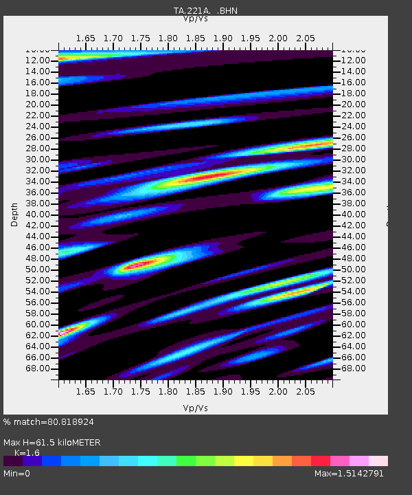
| Estimated Moho Depth: |
61.5 km |
| Estimated Crust Vp/Vs: |
1.60 |
| Assumed Crust Vp: |
6.502 km/s |
| Estimated Crust Vs: |
4.063 km/s |
| Estimated Crust Poisson's Ratio: |
0.18 |
|
| Radial Match: |
80.818924 % |
| Radial Bump: |
400 |
| Transverse Match: |
79.944664 % |
| Transverse Bump: |
400 |
| SOD ConfigId: |
2622 |
| Insert Time: |
2010-03-06 12:37:24.413 +0000 |
| GWidth: |
2.5 |
| Max Bumps: |
400 |
| Tol: |
0.001 |
|

Signal To Noise
| Channel | StoN | STA | LTA |
| TA:221A: :BHN:20090910T02:57:37.850Z | 6.039054 | 8.605496E-7 | 1.4249743E-7 |
| TA:221A: :BHE:20090910T02:57:37.850Z | 1.9964112 | 4.3036536E-7 | 2.155695E-7 |
| TA:221A: :BHZ:20090910T02:57:37.850Z | 1.2492012 | 2.1123245E-7 | 1.6909401E-7 |
| Arrivals |
| Ps | 5.9 SECOND |
| PpPs | 24 SECOND |
| PsPs/PpSs | 30 SECOND |


