You are here: Home > Network List > AE - Arizona Broadband Seismic Network Stations List
> Station BABIT Valle/Cataract Creek > Earthquake Result Viewer
BABIT Valle/Cataract Creek - Earthquake Result Viewer
| Earthquake location: |
Vanuatu Islands |
| Earthquake latitude/longitude: |
-18.9/169.0 |
| Earthquake time(UTC): |
2018/07/13 (194) 09:46:49 GMT |
| Earthquake Depth: |
169 km |
| Earthquake Magnitude: |
6.4 Mww |
| Earthquake Catalog/Contributor: |
NEIC PDE/us |
|
| Network: |
AE Arizona Broadband Seismic Network |
| Station: |
BABIT Valle/Cataract Creek |
| Lat/Lon: |
35.75 N/112.42 W |
| Elevation: |
1694 m |
|
| Distance: |
92.0 deg |
| Az: |
52.919 deg |
| Baz: |
248.172 deg |
| Ray Param: |
0.041446656 |
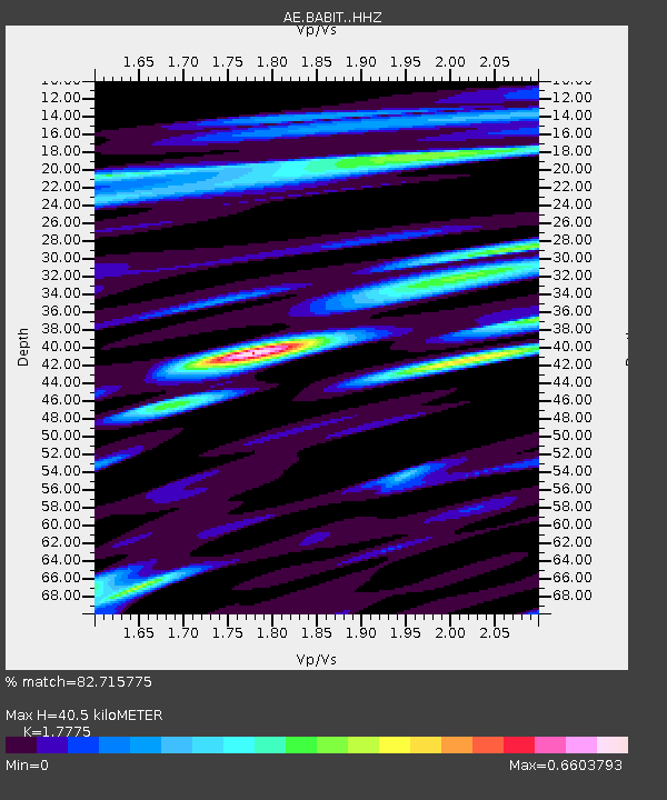
| Estimated Moho Depth: |
40.5 km |
| Estimated Crust Vp/Vs: |
1.78 |
| Assumed Crust Vp: |
6.276 km/s |
| Estimated Crust Vs: |
3.531 km/s |
| Estimated Crust Poisson's Ratio: |
0.27 |
|
| Radial Match: |
82.715775 % |
| Radial Bump: |
400 |
| Transverse Match: |
76.50825 % |
| Transverse Bump: |
400 |
| SOD ConfigId: |
13570011 |
| Insert Time: |
2019-04-30 13:37:23.569 +0000 |
| GWidth: |
2.5 |
| Max Bumps: |
400 |
| Tol: |
0.001 |
|

Signal To Noise
| Channel | StoN | STA | LTA |
| AE:BABIT: :HHZ:20180713T09:59:07.829026Z | 19.02741 | 1.4592957E-6 | 7.669439E-8 |
| AE:BABIT: :HHN:20180713T09:59:07.829026Z | 4.660511 | 2.399699E-7 | 5.1490037E-8 |
| AE:BABIT: :HHE:20180713T09:59:07.829026Z | 5.7368135 | 4.1609607E-7 | 7.2530874E-8 |
| Arrivals |
| Ps | 5.1 SECOND |
| PpPs | 18 SECOND |
| PsPs/PpSs | 23 SECOND |


