You are here: Home > Network List > CI - Caltech Regional Seismic Network Stations List
> Station MPP McPhearson Peak > Earthquake Result Viewer
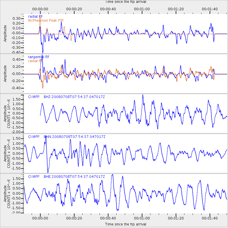
MPP McPhearson Peak - Earthquake Result Viewer
*The percent match for this event was below the threshold and hence no stack was calculated.
| Earthquake location: |
Ryukyu Islands, Japan |
| Earthquake latitude/longitude: |
27.5/128.3 |
| Earthquake time(UTC): |
2008/07/08 (190) 07:42:10 GMT |
| Earthquake Depth: |
43 km |
| Earthquake Magnitude: |
6.0 MB, 5.5 MS, 6.0 MW, 6.0 MW |
| Earthquake Catalog/Contributor: |
WHDF/NEIC |
|
| Network: |
CI Caltech Regional Seismic Network |
| Station: |
MPP McPhearson Peak |
| Lat/Lon: |
34.89 N/119.81 W |
| Elevation: |
1739 m |
|
| Distance: |
90.6 deg |
| Az: |
49.732 deg |
| Baz: |
304.487 deg |
| Ray Param: |
$rayparam |
*The percent match for this event was below the threshold and hence was not used in the summary stack. |
|
| Radial Match: |
46.406136 % |
| Radial Bump: |
348 |
| Transverse Match: |
66.01832 % |
| Transverse Bump: |
333 |
| SOD ConfigId: |
2504 |
| Insert Time: |
2010-02-26 02:04:47.501 +0000 |
| GWidth: |
2.5 |
| Max Bumps: |
400 |
| Tol: |
0.001 |
|
Signal To Noise
| Channel | StoN | STA | LTA |
| CI:MPP: :BHN:20080708T07:54:37.047017Z | 1.4120145 | 8.7433335E-7 | 6.192099E-7 |
| CI:MPP: :BHE:20080708T07:54:37.047017Z | 0.66449124 | 4.1157352E-7 | 6.193814E-7 |
| CI:MPP: :BHZ:20080708T07:54:37.047017Z | 0.9241228 | 5.166257E-7 | 5.590444E-7 |
| Arrivals |
| Ps | |
| PpPs | |
| PsPs/PpSs | |


