You are here: Home > Network List > TA - USArray Transportable Network (new EarthScope stations) Stations List
> Station 221A Mesquite Ranch, Deming, NM, USA > Earthquake Result Viewer
221A Mesquite Ranch, Deming, NM, USA - Earthquake Result Viewer
| Earthquake location: |
Kuril Islands |
| Earthquake latitude/longitude: |
46.0/151.4 |
| Earthquake time(UTC): |
2009/04/18 (108) 19:17:58 GMT |
| Earthquake Depth: |
35 km |
| Earthquake Magnitude: |
6.3 MB, 6.3 MS, 6.6 MW, 6.4 MW |
| Earthquake Catalog/Contributor: |
WHDF/NEIC |
|
| Network: |
TA USArray Transportable Network (new EarthScope stations) |
| Station: |
221A Mesquite Ranch, Deming, NM, USA |
| Lat/Lon: |
32.01 N/107.78 W |
| Elevation: |
1277 m |
|
| Distance: |
74.5 deg |
| Az: |
60.005 deg |
| Baz: |
314.73 deg |
| Ray Param: |
0.052247163 |
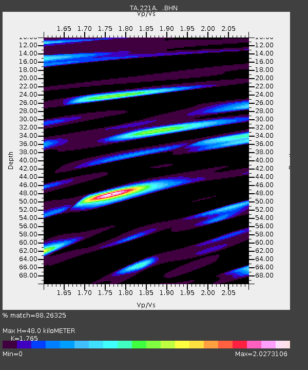
| Estimated Moho Depth: |
48.0 km |
| Estimated Crust Vp/Vs: |
1.76 |
| Assumed Crust Vp: |
6.502 km/s |
| Estimated Crust Vs: |
3.684 km/s |
| Estimated Crust Poisson's Ratio: |
0.26 |
|
| Radial Match: |
88.26325 % |
| Radial Bump: |
400 |
| Transverse Match: |
84.12995 % |
| Transverse Bump: |
400 |
| SOD ConfigId: |
2658 |
| Insert Time: |
2010-03-06 12:37:31.601 +0000 |
| GWidth: |
2.5 |
| Max Bumps: |
400 |
| Tol: |
0.001 |
|
Signal To Noise
| Channel | StoN | STA | LTA |
| TA:221A: :BHN:20090418T19:29:02.82502Z | 10.493968 | 1.0431676E-6 | 9.94064E-8 |
| TA:221A: :BHE:20090418T19:29:02.82502Z | 1.2471539 | 5.0319244E-7 | 4.0347263E-7 |
| TA:221A: :BHZ:20090418T19:29:02.82502Z | 1.1231622 | 3.010468E-7 | 2.6803505E-7 |
| Arrivals |
| Ps | 5.8 SECOND |
| PpPs | 20 SECOND |
| PsPs/PpSs | 26 SECOND |


