You are here: Home > Network List > CI - Caltech Regional Seismic Network Stations List
> Station MPP McPhearson Peak > Earthquake Result Viewer
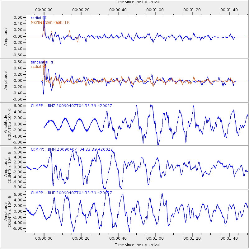
MPP McPhearson Peak - Earthquake Result Viewer
*The percent match for this event was below the threshold and hence no stack was calculated.
| Earthquake location: |
Kuril Islands |
| Earthquake latitude/longitude: |
46.0/151.5 |
| Earthquake time(UTC): |
2009/04/07 (097) 04:23:33 GMT |
| Earthquake Depth: |
31 km |
| Earthquake Magnitude: |
6.5 MB, 6.8 MS, 6.9 MW, 6.9 MW |
| Earthquake Catalog/Contributor: |
WHDF/NEIC |
|
| Network: |
CI Caltech Regional Seismic Network |
| Station: |
MPP McPhearson Peak |
| Lat/Lon: |
34.89 N/119.81 W |
| Elevation: |
1739 m |
|
| Distance: |
65.0 deg |
| Az: |
65.039 deg |
| Baz: |
309.819 deg |
| Ray Param: |
$rayparam |
*The percent match for this event was below the threshold and hence was not used in the summary stack. |
|
| Radial Match: |
84.98926 % |
| Radial Bump: |
400 |
| Transverse Match: |
39.579277 % |
| Transverse Bump: |
400 |
| SOD ConfigId: |
2658 |
| Insert Time: |
2010-02-26 02:04:48.176 +0000 |
| GWidth: |
2.5 |
| Max Bumps: |
400 |
| Tol: |
0.001 |
|
Signal To Noise
| Channel | StoN | STA | LTA |
| CI:MPP: :BHN:20090407T04:33:39.42002Z | 3.4593613 | 3.2584298E-6 | 9.4191654E-7 |
| CI:MPP: :BHE:20090407T04:33:39.42002Z | 1.2357512 | 1.5143906E-6 | 1.2254819E-6 |
| CI:MPP: :BHZ:20090407T04:33:39.42002Z | 1.6720054 | 2.1415667E-6 | 1.2808373E-6 |
| Arrivals |
| Ps | |
| PpPs | |
| PsPs/PpSs | |


