You are here: Home > Network List > US - United States National Seismic Network Stations List
> Station DGMT Dagmar, Montana, USA > Earthquake Result Viewer
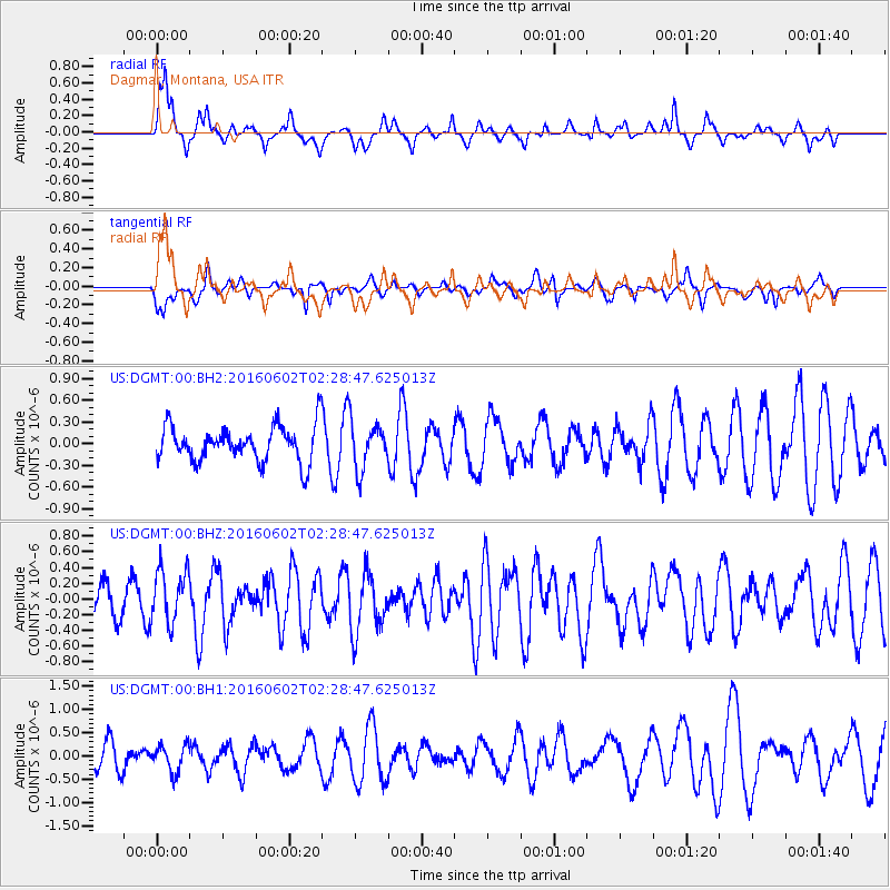
DGMT Dagmar, Montana, USA - Earthquake Result Viewer
*The percent match for this event was below the threshold and hence no stack was calculated.
| Earthquake location: |
Off Coast Of Jalisco, Mexico |
| Earthquake latitude/longitude: |
18.0/-105.9 |
| Earthquake time(UTC): |
2016/06/02 (154) 02:23:06 GMT |
| Earthquake Depth: |
10 km |
| Earthquake Magnitude: |
5.8 MWW, 5.8 MWC |
| Earthquake Catalog/Contributor: |
NEIC PDE/NEIC COMCAT |
|
| Network: |
US United States National Seismic Network |
| Station: |
DGMT Dagmar, Montana, USA |
| Lat/Lon: |
48.47 N/104.20 W |
| Elevation: |
0.0 m |
|
| Distance: |
30.4 deg |
| Az: |
2.182 deg |
| Baz: |
183.121 deg |
| Ray Param: |
$rayparam |
*The percent match for this event was below the threshold and hence was not used in the summary stack. |
|
| Radial Match: |
67.626564 % |
| Radial Bump: |
304 |
| Transverse Match: |
47.655495 % |
| Transverse Bump: |
343 |
| SOD ConfigId: |
1609551 |
| Insert Time: |
2016-06-22 14:52:17.252 +0000 |
| GWidth: |
2.5 |
| Max Bumps: |
400 |
| Tol: |
0.001 |
|
Signal To Noise
| Channel | StoN | STA | LTA |
| US:DGMT:00:BHZ:20160602T02:28:47.625013Z | 2.0737016 | 3.4336463E-7 | 1.6558054E-7 |
| US:DGMT:00:BH1:20160602T02:28:47.625013Z | 0.9164092 | 2.888519E-7 | 3.1519969E-7 |
| US:DGMT:00:BH2:20160602T02:28:47.625013Z | 1.3102292 | 3.235107E-7 | 2.4691155E-7 |
| Arrivals |
| Ps | |
| PpPs | |
| PsPs/PpSs | |


