You are here: Home > Network List > CI - Caltech Regional Seismic Network Stations List
> Station BAR Barrett, Tecate, CA, USA > Earthquake Result Viewer
BAR Barrett, Tecate, CA, USA - Earthquake Result Viewer
| Earthquake location: |
Vanuatu Islands |
| Earthquake latitude/longitude: |
-18.9/169.0 |
| Earthquake time(UTC): |
2018/07/13 (194) 09:46:49 GMT |
| Earthquake Depth: |
169 km |
| Earthquake Magnitude: |
6.4 Mww |
| Earthquake Catalog/Contributor: |
NEIC PDE/us |
|
| Network: |
CI Caltech Regional Seismic Network |
| Station: |
BAR Barrett, Tecate, CA, USA |
| Lat/Lon: |
32.68 N/116.67 W |
| Elevation: |
521 m |
|
| Distance: |
87.6 deg |
| Az: |
54.354 deg |
| Baz: |
245.797 deg |
| Ray Param: |
0.042852554 |
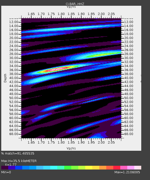
| Estimated Moho Depth: |
35.5 km |
| Estimated Crust Vp/Vs: |
1.77 |
| Assumed Crust Vp: |
6.264 km/s |
| Estimated Crust Vs: |
3.539 km/s |
| Estimated Crust Poisson's Ratio: |
0.27 |
|
| Radial Match: |
91.485535 % |
| Radial Bump: |
368 |
| Transverse Match: |
95.64206 % |
| Transverse Bump: |
324 |
| SOD ConfigId: |
13570011 |
| Insert Time: |
2019-04-30 13:40:27.245 +0000 |
| GWidth: |
2.5 |
| Max Bumps: |
400 |
| Tol: |
0.001 |
|
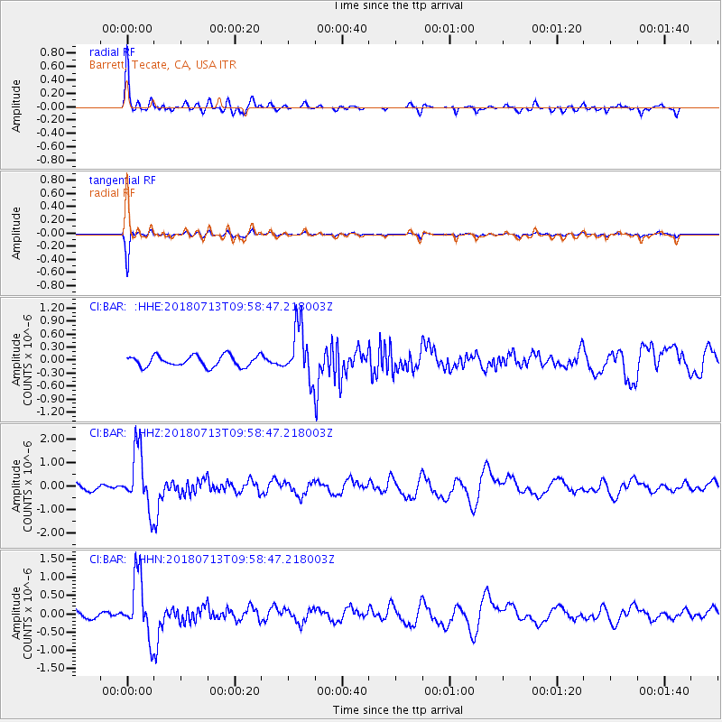
Signal To Noise
| Channel | StoN | STA | LTA |
| CI:BAR: :HHZ:20180713T09:58:47.218003Z | 6.562041 | 1.2704255E-6 | 1.936022E-7 |
| CI:BAR: :HHN:20180713T09:58:47.218003Z | 6.5975294 | 8.399829E-7 | 1.2731779E-7 |
| CI:BAR: :HHE:20180713T09:58:47.218003Z | 4.7845798 | 6.012777E-7 | 1.256699E-7 |
| Arrivals |
| Ps | 4.5 SECOND |
| PpPs | 15 SECOND |
| PsPs/PpSs | 20 SECOND |


