You are here: Home > Network List > TA - USArray Transportable Network (new EarthScope stations) Stations List
> Station 221A Mesquite Ranch, Deming, NM, USA > Earthquake Result Viewer
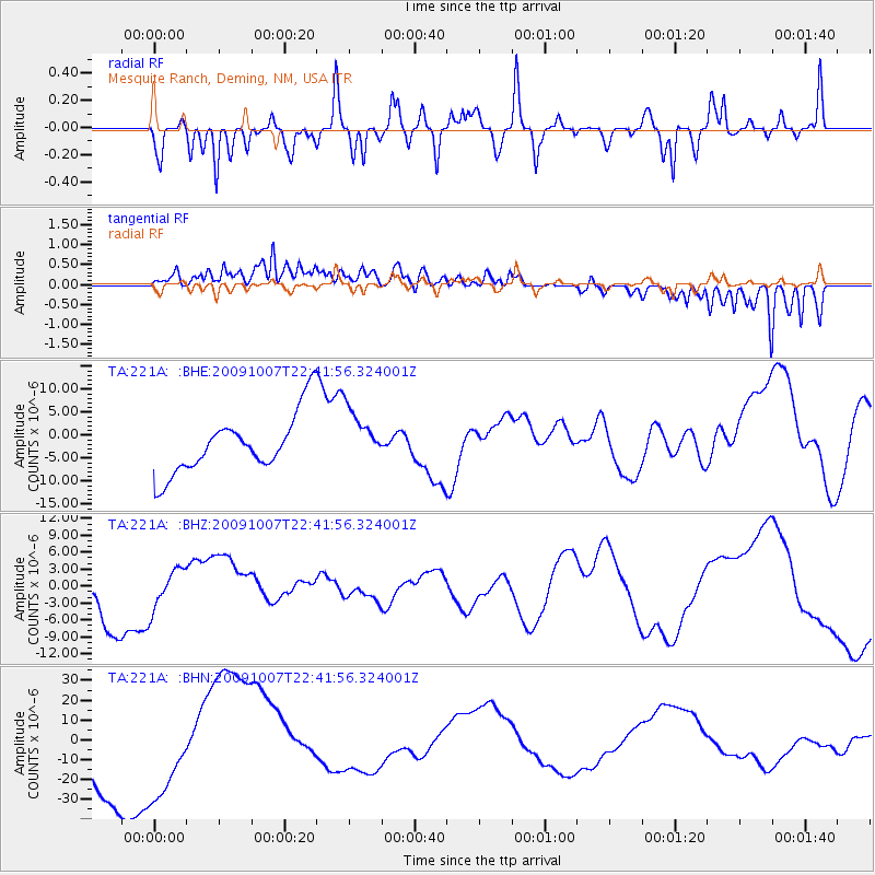
221A Mesquite Ranch, Deming, NM, USA - Earthquake Result Viewer
*The percent match for this event was below the threshold and hence no stack was calculated.
| Earthquake location: |
Santa Cruz Islands |
| Earthquake latitude/longitude: |
-11.5/166.0 |
| Earthquake time(UTC): |
2009/10/07 (280) 22:29:18 GMT |
| Earthquake Depth: |
35 km |
| Earthquake Magnitude: |
5.5 MB |
| Earthquake Catalog/Contributor: |
WHDF/NEIC |
|
| Network: |
TA USArray Transportable Network (new EarthScope stations) |
| Station: |
221A Mesquite Ranch, Deming, NM, USA |
| Lat/Lon: |
32.01 N/107.78 W |
| Elevation: |
1277 m |
|
| Distance: |
92.8 deg |
| Az: |
58.072 deg |
| Baz: |
258.289 deg |
| Ray Param: |
$rayparam |
*The percent match for this event was below the threshold and hence was not used in the summary stack. |
|
| Radial Match: |
48.22447 % |
| Radial Bump: |
400 |
| Transverse Match: |
52.183987 % |
| Transverse Bump: |
400 |
| SOD ConfigId: |
2622 |
| Insert Time: |
2010-03-06 12:39:01.275 +0000 |
| GWidth: |
2.5 |
| Max Bumps: |
400 |
| Tol: |
0.001 |
|
Signal To Noise
| Channel | StoN | STA | LTA |
| TA:221A: :BHZ:20091007T22:41:56.324001Z | 0.9594633 | 3.575078E-6 | 3.7261227E-6 |
| TA:221A: :BHN:20091007T22:41:56.324001Z | 1.4150501 | 2.798365E-5 | 1.9775729E-5 |
| TA:221A: :BHE:20091007T22:41:56.324001Z | 0.9253136 | 5.8947044E-6 | 6.3704933E-6 |
| Arrivals |
| Ps | |
| PpPs | |
| PsPs/PpSs | |


