You are here: Home > Network List > TA - USArray Transportable Network (new EarthScope stations) Stations List
> Station 221A Mesquite Ranch, Deming, NM, USA > Earthquake Result Viewer
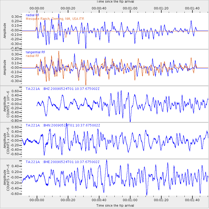
221A Mesquite Ranch, Deming, NM, USA - Earthquake Result Viewer
*The percent match for this event was below the threshold and hence no stack was calculated.
| Earthquake location: |
Kermadec Islands Region |
| Earthquake latitude/longitude: |
-31.5/-177.7 |
| Earthquake time(UTC): |
2009/05/24 (144) 00:58:02 GMT |
| Earthquake Depth: |
4.0 km |
| Earthquake Magnitude: |
5.6 MB, 5.9 MS, 6.0 MW, 5.8 MW |
| Earthquake Catalog/Contributor: |
WHDF/NEIC |
|
| Network: |
TA USArray Transportable Network (new EarthScope stations) |
| Station: |
221A Mesquite Ranch, Deming, NM, USA |
| Lat/Lon: |
32.01 N/107.78 W |
| Elevation: |
1277 m |
|
| Distance: |
91.4 deg |
| Az: |
52.947 deg |
| Baz: |
233.384 deg |
| Ray Param: |
$rayparam |
*The percent match for this event was below the threshold and hence was not used in the summary stack. |
|
| Radial Match: |
57.78804 % |
| Radial Bump: |
400 |
| Transverse Match: |
54.85379 % |
| Transverse Bump: |
400 |
| SOD ConfigId: |
2648 |
| Insert Time: |
2010-03-06 12:39:05.456 +0000 |
| GWidth: |
2.5 |
| Max Bumps: |
400 |
| Tol: |
0.001 |
|
Signal To Noise
| Channel | StoN | STA | LTA |
| TA:221A: :BHN:20090524T01:10:37.675002Z | 2.8246543 | 2.1929415E-7 | 7.763575E-8 |
| TA:221A: :BHE:20090524T01:10:37.675002Z | 0.9274742 | 1.118155E-7 | 1.2055915E-7 |
| TA:221A: :BHZ:20090524T01:10:37.675002Z | 0.6890111 | 1.4090202E-7 | 2.0449892E-7 |
| Arrivals |
| Ps | |
| PpPs | |
| PsPs/PpSs | |


