You are here: Home > Network List > JP - Japan Meteorological Agency Seismic Network Stations List
> Station JTM Aomori Tenma > Earthquake Result Viewer
JTM Aomori Tenma - Earthquake Result Viewer
| Earthquake location: |
Vanuatu Islands |
| Earthquake latitude/longitude: |
-18.9/169.0 |
| Earthquake time(UTC): |
2018/07/13 (194) 09:46:49 GMT |
| Earthquake Depth: |
169 km |
| Earthquake Magnitude: |
6.4 Mww |
| Earthquake Catalog/Contributor: |
NEIC PDE/us |
|
| Network: |
JP Japan Meteorological Agency Seismic Network |
| Station: |
JTM Aomori Tenma |
| Lat/Lon: |
40.79 N/141.06 E |
| Elevation: |
130 m |
|
| Distance: |
64.9 deg |
| Az: |
336.844 deg |
| Baz: |
150.644 deg |
| Ray Param: |
0.058161043 |
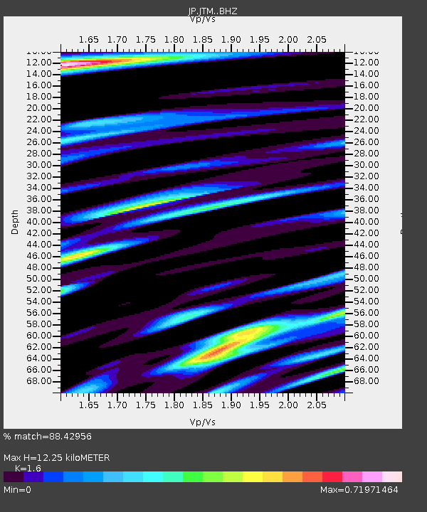
| Estimated Moho Depth: |
12.25 km |
| Estimated Crust Vp/Vs: |
1.60 |
| Assumed Crust Vp: |
6.468 km/s |
| Estimated Crust Vs: |
4.042 km/s |
| Estimated Crust Poisson's Ratio: |
0.18 |
|
| Radial Match: |
88.42956 % |
| Radial Bump: |
400 |
| Transverse Match: |
80.819435 % |
| Transverse Bump: |
400 |
| SOD ConfigId: |
13570011 |
| Insert Time: |
2019-04-30 13:42:24.103 +0000 |
| GWidth: |
2.5 |
| Max Bumps: |
400 |
| Tol: |
0.001 |
|

Signal To Noise
| Channel | StoN | STA | LTA |
| JP:JTM: :BHZ:20180713T09:56:39.749985Z | 8.218569 | 9.506682E-7 | 1.1567321E-7 |
| JP:JTM: :BHN:20180713T09:56:39.749985Z | 4.4014297 | 4.2695996E-7 | 9.700484E-8 |
| JP:JTM: :BHE:20180713T09:56:39.749985Z | 2.3490262 | 1.8055098E-7 | 7.686206E-8 |
| Arrivals |
| Ps | 1.2 SECOND |
| PpPs | 4.7 SECOND |
| PsPs/PpSs | 5.9 SECOND |


