You are here: Home > Network List > TA - USArray Transportable Network (new EarthScope stations) Stations List
> Station 221A Mesquite Ranch, Deming, NM, USA > Earthquake Result Viewer
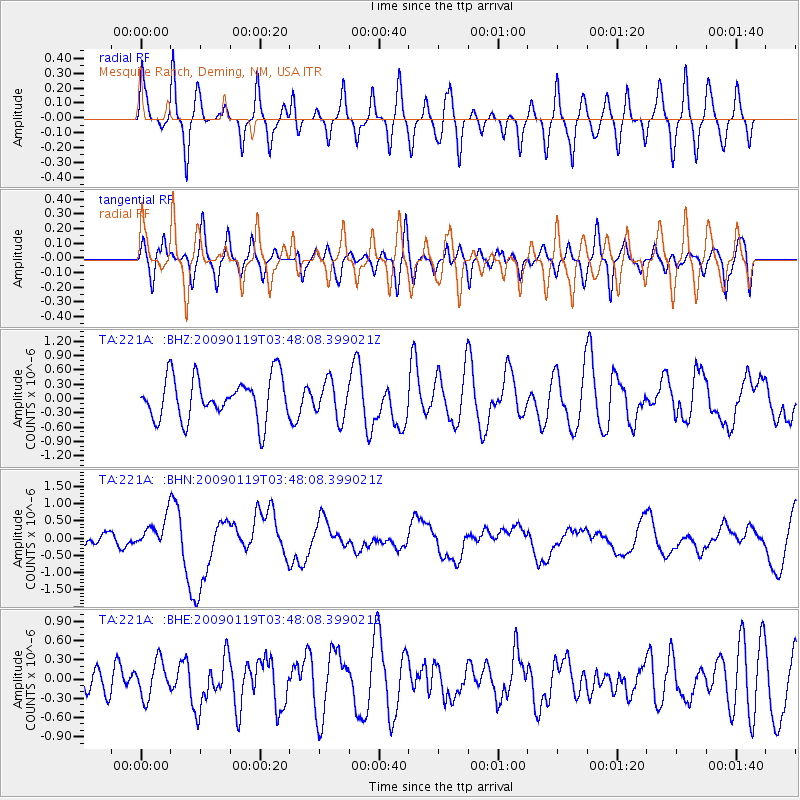
221A Mesquite Ranch, Deming, NM, USA - Earthquake Result Viewer
*The percent match for this event was below the threshold and hence no stack was calculated.
| Earthquake location: |
Southeast Of Loyalty Islands |
| Earthquake latitude/longitude: |
-22.6/170.9 |
| Earthquake time(UTC): |
2009/01/19 (019) 03:35:18 GMT |
| Earthquake Depth: |
12 km |
| Earthquake Magnitude: |
5.7 MB, 6.4 MS, 6.5 MW, 6.5 MW |
| Earthquake Catalog/Contributor: |
WHDF/NEIC |
|
| Network: |
TA USArray Transportable Network (new EarthScope stations) |
| Station: |
221A Mesquite Ranch, Deming, NM, USA |
| Lat/Lon: |
32.01 N/107.78 W |
| Elevation: |
1277 m |
|
| Distance: |
94.8 deg |
| Az: |
57.427 deg |
| Baz: |
246.448 deg |
| Ray Param: |
$rayparam |
*The percent match for this event was below the threshold and hence was not used in the summary stack. |
|
| Radial Match: |
55.720642 % |
| Radial Bump: |
400 |
| Transverse Match: |
61.162464 % |
| Transverse Bump: |
400 |
| SOD ConfigId: |
2658 |
| Insert Time: |
2010-03-06 12:39:43.407 +0000 |
| GWidth: |
2.5 |
| Max Bumps: |
400 |
| Tol: |
0.001 |
|
Signal To Noise
| Channel | StoN | STA | LTA |
| TA:221A: :BHN:20090119T03:48:08.399021Z | 2.3520877 | 4.3837105E-7 | 1.8637529E-7 |
| TA:221A: :BHE:20090119T03:48:08.399021Z | 0.72449327 | 2.7931384E-7 | 3.8552994E-7 |
| TA:221A: :BHZ:20090119T03:48:08.399021Z | 0.8728394 | 3.857235E-7 | 4.4191808E-7 |
| Arrivals |
| Ps | |
| PpPs | |
| PsPs/PpSs | |


