You are here: Home > Network List > TA - USArray Transportable Network (new EarthScope stations) Stations List
> Station E18K Tukpahlearik Creek, AK, USA > Earthquake Result Viewer
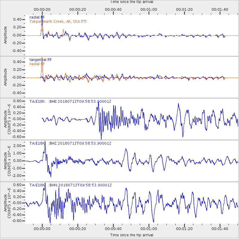
E18K Tukpahlearik Creek, AK, USA - Earthquake Result Viewer

| Earthquake location: |
Vanuatu Islands |
| Earthquake latitude/longitude: |
-18.9/169.0 |
| Earthquake time(UTC): |
2018/07/13 (194) 09:46:49 GMT |
| Earthquake Depth: |
169 km |
| Earthquake Magnitude: |
6.4 Mww |
| Earthquake Catalog/Contributor: |
NEIC PDE/us |
|
| Network: |
TA USArray Transportable Network (new EarthScope stations) |
| Station: |
E18K Tukpahlearik Creek, AK, USA |
| Lat/Lon: |
67.42 N/160.60 W |
| Elevation: |
297 m |
|
| Distance: |
89.0 deg |
| Az: |
11.262 deg |
| Baz: |
208.601 deg |
| Ray Param: |
0.041814722 |
| Estimated Moho Depth: |
69.75 km |
| Estimated Crust Vp/Vs: |
1.72 |
| Assumed Crust Vp: |
6.276 km/s |
| Estimated Crust Vs: |
3.643 km/s |
| Estimated Crust Poisson's Ratio: |
0.25 |
|
| Radial Match: |
91.79599 % |
| Radial Bump: |
400 |
| Transverse Match: |
78.47242 % |
| Transverse Bump: |
400 |
| SOD ConfigId: |
13570011 |
| Insert Time: |
2019-04-30 13:44:16.991 +0000 |
| GWidth: |
2.5 |
| Max Bumps: |
400 |
| Tol: |
0.001 |
|
Signal To Noise
| Channel | StoN | STA | LTA |
| TA:E18K: :BHZ:20180713T09:58:53.90001Z | 18.455566 | 1.1443105E-6 | 6.2003544E-8 |
| TA:E18K: :BHN:20180713T09:58:53.90001Z | 6.5860376 | 3.5704454E-7 | 5.4212347E-8 |
| TA:E18K: :BHE:20180713T09:58:53.90001Z | 6.373004 | 3.271679E-7 | 5.133653E-8 |
| Arrivals |
| Ps | 8.2 SECOND |
| PpPs | 30 SECOND |
| PsPs/PpSs | 38 SECOND |


