You are here: Home > Network List > TA - USArray Transportable Network (new EarthScope stations) Stations List
> Station F20K Avaraart Lake, AK, USA > Earthquake Result Viewer
F20K Avaraart Lake, AK, USA - Earthquake Result Viewer

| Earthquake location: |
Vanuatu Islands |
| Earthquake latitude/longitude: |
-18.9/169.0 |
| Earthquake time(UTC): |
2018/07/13 (194) 09:46:49 GMT |
| Earthquake Depth: |
169 km |
| Earthquake Magnitude: |
6.4 Mww |
| Earthquake Catalog/Contributor: |
NEIC PDE/us |
|
| Network: |
TA USArray Transportable Network (new EarthScope stations) |
| Station: |
F20K Avaraart Lake, AK, USA |
| Lat/Lon: |
67.05 N/155.73 W |
| Elevation: |
136 m |
|
| Distance: |
89.6 deg |
| Az: |
13.083 deg |
| Baz: |
213.117 deg |
| Ray Param: |
0.04169483 |
| Estimated Moho Depth: |
69.25 km |
| Estimated Crust Vp/Vs: |
1.98 |
| Assumed Crust Vp: |
6.522 km/s |
| Estimated Crust Vs: |
3.298 km/s |
| Estimated Crust Poisson's Ratio: |
0.33 |
|
| Radial Match: |
83.76708 % |
| Radial Bump: |
400 |
| Transverse Match: |
77.85986 % |
| Transverse Bump: |
400 |
| SOD ConfigId: |
13570011 |
| Insert Time: |
2019-04-30 13:44:31.780 +0000 |
| GWidth: |
2.5 |
| Max Bumps: |
400 |
| Tol: |
0.001 |
|
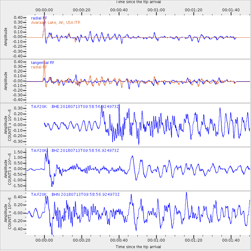
Signal To Noise
| Channel | StoN | STA | LTA |
| TA:F20K: :BHZ:20180713T09:58:56.924973Z | 12.764309 | 9.4404015E-7 | 7.395936E-8 |
| TA:F20K: :BHN:20180713T09:58:56.924973Z | 9.691774 | 2.7041955E-7 | 2.7901967E-8 |
| TA:F20K: :BHE:20180713T09:58:56.924973Z | 3.259557 | 1.5635928E-7 | 4.7969486E-8 |
| Arrivals |
| Ps | 11 SECOND |
| PpPs | 31 SECOND |
| PsPs/PpSs | 42 SECOND |


