You are here: Home > Network List > TA - USArray Transportable Network (new EarthScope stations) Stations List
> Station G16K Koyuk River, AK, USA > Earthquake Result Viewer
G16K Koyuk River, AK, USA - Earthquake Result Viewer
| Earthquake location: |
Vanuatu Islands |
| Earthquake latitude/longitude: |
-18.9/169.0 |
| Earthquake time(UTC): |
2018/07/13 (194) 09:46:49 GMT |
| Earthquake Depth: |
169 km |
| Earthquake Magnitude: |
6.4 Mww |
| Earthquake Catalog/Contributor: |
NEIC PDE/us |
|
| Network: |
TA USArray Transportable Network (new EarthScope stations) |
| Station: |
G16K Koyuk River, AK, USA |
| Lat/Lon: |
65.39 N/162.35 W |
| Elevation: |
169 m |
|
| Distance: |
86.8 deg |
| Az: |
11.588 deg |
| Baz: |
207.009 deg |
| Ray Param: |
0.043367926 |
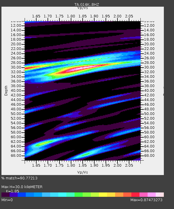
| Estimated Moho Depth: |
30.0 km |
| Estimated Crust Vp/Vs: |
1.85 |
| Assumed Crust Vp: |
6.276 km/s |
| Estimated Crust Vs: |
3.392 km/s |
| Estimated Crust Poisson's Ratio: |
0.29 |
|
| Radial Match: |
90.77213 % |
| Radial Bump: |
400 |
| Transverse Match: |
83.97765 % |
| Transverse Bump: |
400 |
| SOD ConfigId: |
13570011 |
| Insert Time: |
2019-04-30 13:44:40.037 +0000 |
| GWidth: |
2.5 |
| Max Bumps: |
400 |
| Tol: |
0.001 |
|

Signal To Noise
| Channel | StoN | STA | LTA |
| TA:G16K: :BHZ:20180713T09:58:43.824998Z | 24.556585 | 1.6300986E-6 | 6.6381325E-8 |
| TA:G16K: :BHN:20180713T09:58:43.824998Z | 6.6350207 | 4.8496076E-7 | 7.3091066E-8 |
| TA:G16K: :BHE:20180713T09:58:43.824998Z | 4.809322 | 2.6621737E-7 | 5.535445E-8 |
| Arrivals |
| Ps | 4.1 SECOND |
| PpPs | 13 SECOND |
| PsPs/PpSs | 17 SECOND |


