You are here: Home > Network List > TA - USArray Transportable Network (new EarthScope stations) Stations List
> Station L20K Farewell, AK, USA > Earthquake Result Viewer
L20K Farewell, AK, USA - Earthquake Result Viewer
| Earthquake location: |
Vanuatu Islands |
| Earthquake latitude/longitude: |
-18.9/169.0 |
| Earthquake time(UTC): |
2018/07/13 (194) 09:46:49 GMT |
| Earthquake Depth: |
169 km |
| Earthquake Magnitude: |
6.4 Mww |
| Earthquake Catalog/Contributor: |
NEIC PDE/us |
|
| Network: |
TA USArray Transportable Network (new EarthScope stations) |
| Station: |
L20K Farewell, AK, USA |
| Lat/Lon: |
62.48 N/153.88 W |
| Elevation: |
673 m |
|
| Distance: |
86.3 deg |
| Az: |
16.307 deg |
| Baz: |
214.901 deg |
| Ray Param: |
0.0437851 |
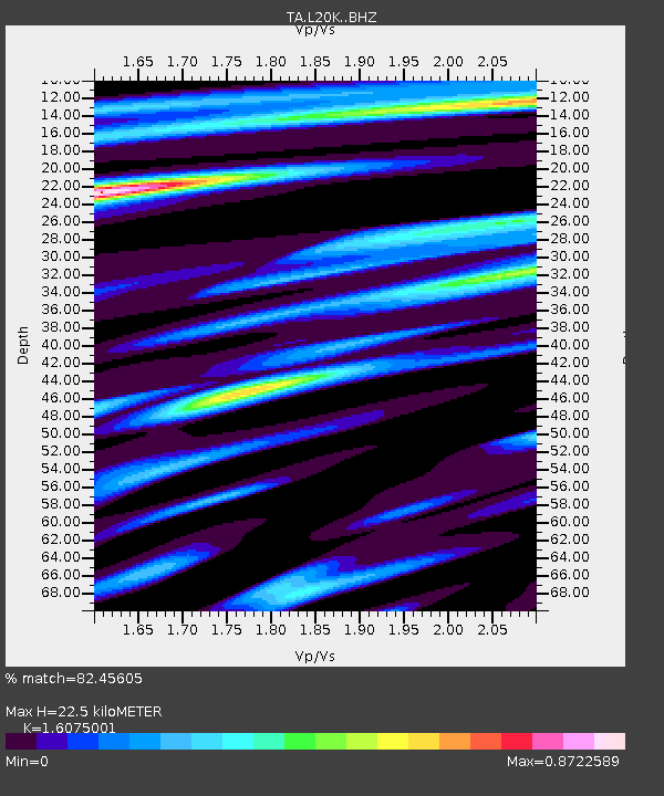
| Estimated Moho Depth: |
22.5 km |
| Estimated Crust Vp/Vs: |
1.61 |
| Assumed Crust Vp: |
6.566 km/s |
| Estimated Crust Vs: |
4.085 km/s |
| Estimated Crust Poisson's Ratio: |
0.18 |
|
| Radial Match: |
82.45605 % |
| Radial Bump: |
400 |
| Transverse Match: |
73.1315 % |
| Transverse Bump: |
400 |
| SOD ConfigId: |
13570011 |
| Insert Time: |
2019-04-30 13:45:26.301 +0000 |
| GWidth: |
2.5 |
| Max Bumps: |
400 |
| Tol: |
0.001 |
|

Signal To Noise
| Channel | StoN | STA | LTA |
| TA:L20K: :BHZ:20180713T09:58:41.02501Z | 23.020443 | 1.9967829E-6 | 8.6739554E-8 |
| TA:L20K: :BHN:20180713T09:58:41.02501Z | 3.5853868 | 4.318267E-7 | 1.2044076E-7 |
| TA:L20K: :BHE:20180713T09:58:41.02501Z | 5.170577 | 6.510817E-7 | 1.2592051E-7 |
| Arrivals |
| Ps | 2.1 SECOND |
| PpPs | 8.7 SECOND |
| PsPs/PpSs | 11 SECOND |


