You are here: Home > Network List > TA - USArray Transportable Network (new EarthScope stations) Stations List
> Station O20A White River City, CO, USA > Earthquake Result Viewer
O20A White River City, CO, USA - Earthquake Result Viewer
| Earthquake location: |
Eastern Honshu, Japan |
| Earthquake latitude/longitude: |
39.8/141.5 |
| Earthquake time(UTC): |
2008/07/23 (205) 15:26:19 GMT |
| Earthquake Depth: |
108 km |
| Earthquake Magnitude: |
6.6 MB, 6.8 MW, 6.8 MW |
| Earthquake Catalog/Contributor: |
WHDF/NEIC |
|
| Network: |
TA USArray Transportable Network (new EarthScope stations) |
| Station: |
O20A White River City, CO, USA |
| Lat/Lon: |
40.13 N/108.24 W |
| Elevation: |
1915 m |
|
| Distance: |
78.2 deg |
| Az: |
47.273 deg |
| Baz: |
312.426 deg |
| Ray Param: |
0.04955541 |
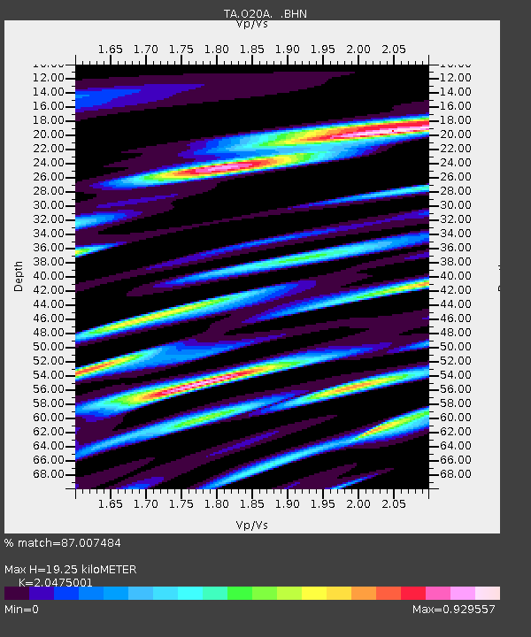
| Estimated Moho Depth: |
19.25 km |
| Estimated Crust Vp/Vs: |
2.05 |
| Assumed Crust Vp: |
6.207 km/s |
| Estimated Crust Vs: |
3.031 km/s |
| Estimated Crust Poisson's Ratio: |
0.34 |
|
| Radial Match: |
87.007484 % |
| Radial Bump: |
400 |
| Transverse Match: |
79.79808 % |
| Transverse Bump: |
400 |
| SOD ConfigId: |
2504 |
| Insert Time: |
2010-03-06 12:40:59.584 +0000 |
| GWidth: |
2.5 |
| Max Bumps: |
400 |
| Tol: |
0.001 |
|

Signal To Noise
| Channel | StoN | STA | LTA |
| TA:O20A: :BHN:20080723T15:37:36.525012Z | 24.55119 | 5.7079233E-6 | 2.324907E-7 |
| TA:O20A: :BHE:20080723T15:37:36.525012Z | 4.696383 | 8.869915E-7 | 1.8886693E-7 |
| TA:O20A: :BHZ:20080723T15:37:36.525012Z | 3.1797066 | 9.943784E-7 | 3.1272646E-7 |
| Arrivals |
| Ps | 3.3 SECOND |
| PpPs | 9.2 SECOND |
| PsPs/PpSs | 13 SECOND |


