You are here: Home > Network List > XO18 - AACE: Alaska Amphibious Community seismic Experimen Stations List
> Station KT06 Harverster Island, AK > Earthquake Result Viewer
KT06 Harverster Island, AK - Earthquake Result Viewer
| Earthquake location: |
Vanuatu Islands |
| Earthquake latitude/longitude: |
-18.9/169.0 |
| Earthquake time(UTC): |
2018/07/13 (194) 09:46:49 GMT |
| Earthquake Depth: |
169 km |
| Earthquake Magnitude: |
6.4 Mww |
| Earthquake Catalog/Contributor: |
NEIC PDE/us |
|
| Network: |
XO AACE: Alaska Amphibious Community seismic Experimen |
| Station: |
KT06 Harverster Island, AK |
| Lat/Lon: |
57.65 N/154.00 W |
| Elevation: |
46 m |
|
| Distance: |
82.3 deg |
| Az: |
19.046 deg |
| Baz: |
215.067 deg |
| Ray Param: |
0.046608564 |
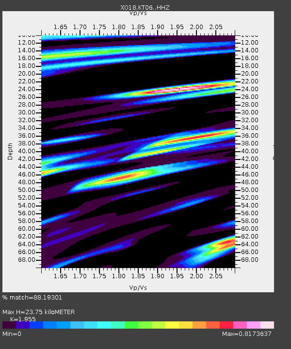
| Estimated Moho Depth: |
23.75 km |
| Estimated Crust Vp/Vs: |
1.96 |
| Assumed Crust Vp: |
6.24 km/s |
| Estimated Crust Vs: |
3.192 km/s |
| Estimated Crust Poisson's Ratio: |
0.32 |
|
| Radial Match: |
88.19301 % |
| Radial Bump: |
400 |
| Transverse Match: |
84.22292 % |
| Transverse Bump: |
400 |
| SOD ConfigId: |
13570011 |
| Insert Time: |
2019-04-30 13:47:56.324 +0000 |
| GWidth: |
2.5 |
| Max Bumps: |
400 |
| Tol: |
0.001 |
|

Signal To Noise
| Channel | StoN | STA | LTA |
| XO:KT06: :HHZ:20180713T09:58:20.929978Z | 28.158855 | 3.0065075E-6 | 1.0676952E-7 |
| XO:KT06: :HHN:20180713T09:58:20.929978Z | 5.332091 | 6.511053E-7 | 1.2211069E-7 |
| XO:KT06: :HHE:20180713T09:58:20.929978Z | 6.7173243 | 9.074229E-7 | 1.3508695E-7 |
| Arrivals |
| Ps | 3.7 SECOND |
| PpPs | 11 SECOND |
| PsPs/PpSs | 15 SECOND |


