You are here: Home > Network List > TA - USArray Transportable Network (new EarthScope stations) Stations List
> Station O20A White River City, CO, USA > Earthquake Result Viewer
O20A White River City, CO, USA - Earthquake Result Viewer
| Earthquake location: |
Vanuatu Islands |
| Earthquake latitude/longitude: |
-14.8/168.0 |
| Earthquake time(UTC): |
2008/11/07 (312) 07:19:35 GMT |
| Earthquake Depth: |
13 km |
| Earthquake Magnitude: |
6.0 MB, 6.3 MS, 6.4 MW, 6.4 MW |
| Earthquake Catalog/Contributor: |
WHDF/NEIC |
|
| Network: |
TA USArray Transportable Network (new EarthScope stations) |
| Station: |
O20A White River City, CO, USA |
| Lat/Lon: |
40.13 N/108.24 W |
| Elevation: |
1915 m |
|
| Distance: |
94.7 deg |
| Az: |
49.877 deg |
| Baz: |
254.708 deg |
| Ray Param: |
0.040971458 |
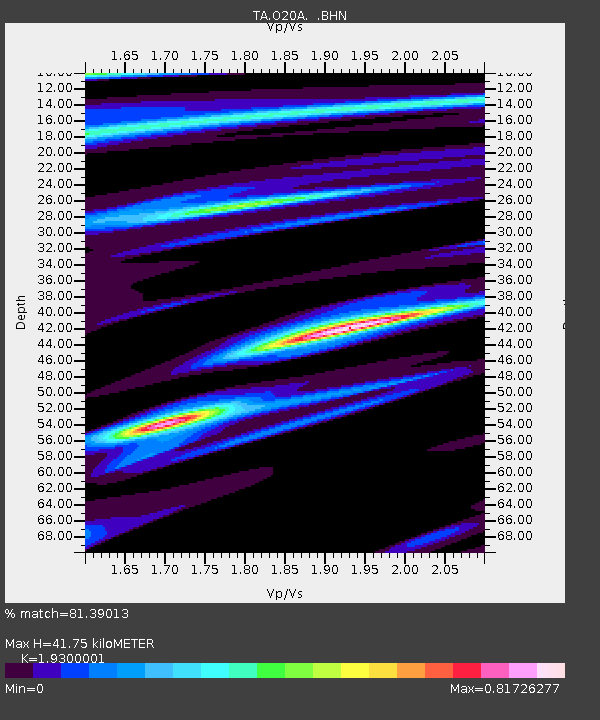
| Estimated Moho Depth: |
41.75 km |
| Estimated Crust Vp/Vs: |
1.93 |
| Assumed Crust Vp: |
6.207 km/s |
| Estimated Crust Vs: |
3.216 km/s |
| Estimated Crust Poisson's Ratio: |
0.32 |
|
| Radial Match: |
81.39013 % |
| Radial Bump: |
318 |
| Transverse Match: |
62.593445 % |
| Transverse Bump: |
322 |
| SOD ConfigId: |
2658 |
| Insert Time: |
2010-03-06 12:41:10.310 +0000 |
| GWidth: |
2.5 |
| Max Bumps: |
400 |
| Tol: |
0.001 |
|

Signal To Noise
| Channel | StoN | STA | LTA |
| TA:O20A: :BHN:20081107T07:32:24.925027Z | 3.3955753 | 4.6851736E-7 | 1.3797879E-7 |
| TA:O20A: :BHE:20081107T07:32:24.925027Z | 1.3135178 | 2.495959E-7 | 1.9002094E-7 |
| TA:O20A: :BHZ:20081107T07:32:24.925027Z | 0.7227561 | 9.357329E-8 | 1.2946732E-7 |
| Arrivals |
| Ps | 6.4 SECOND |
| PpPs | 19 SECOND |
| PsPs/PpSs | 26 SECOND |


