You are here: Home > Network List > TA - USArray Transportable Network (new EarthScope stations) Stations List
> Station O20A White River City, CO, USA > Earthquake Result Viewer
O20A White River City, CO, USA - Earthquake Result Viewer
| Earthquake location: |
Kermadec Islands Region |
| Earthquake latitude/longitude: |
-27.4/-176.3 |
| Earthquake time(UTC): |
2009/02/18 (049) 21:53:45 GMT |
| Earthquake Depth: |
25 km |
| Earthquake Magnitude: |
6.8 MB, 7.2 MS, 6.9 MW, 6.9 MW |
| Earthquake Catalog/Contributor: |
WHDF/NEIC |
|
| Network: |
TA USArray Transportable Network (new EarthScope stations) |
| Station: |
O20A White River City, CO, USA |
| Lat/Lon: |
40.13 N/108.24 W |
| Elevation: |
1915 m |
|
| Distance: |
92.3 deg |
| Az: |
45.385 deg |
| Baz: |
235.621 deg |
| Ray Param: |
0.041476283 |
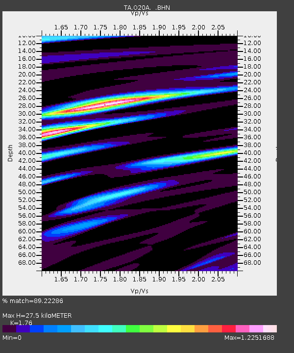
| Estimated Moho Depth: |
27.5 km |
| Estimated Crust Vp/Vs: |
1.76 |
| Assumed Crust Vp: |
6.207 km/s |
| Estimated Crust Vs: |
3.527 km/s |
| Estimated Crust Poisson's Ratio: |
0.26 |
|
| Radial Match: |
89.22286 % |
| Radial Bump: |
400 |
| Transverse Match: |
81.99115 % |
| Transverse Bump: |
400 |
| SOD ConfigId: |
2658 |
| Insert Time: |
2010-03-06 12:41:23.636 +0000 |
| GWidth: |
2.5 |
| Max Bumps: |
400 |
| Tol: |
0.001 |
|
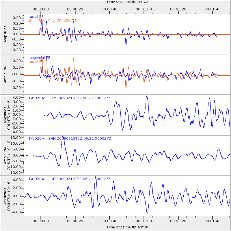
Signal To Noise
| Channel | StoN | STA | LTA |
| TA:O20A: :BHN:20090218T22:06:21.500027Z | 2.2414615 | 1.3466272E-6 | 6.007809E-7 |
| TA:O20A: :BHE:20090218T22:06:21.500027Z | 1.260187 | 5.105865E-7 | 4.0516724E-7 |
| TA:O20A: :BHZ:20090218T22:06:21.500027Z | 1.1255487 | 4.543402E-7 | 4.0366106E-7 |
| Arrivals |
| Ps | 3.4 SECOND |
| PpPs | 12 SECOND |
| PsPs/PpSs | 15 SECOND |


