You are here: Home > Network List > CI - Caltech Regional Seismic Network Stations List
> Station MPP McPhearson Peak > Earthquake Result Viewer
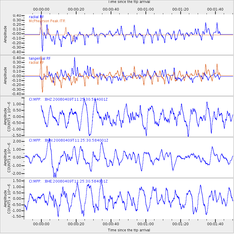
MPP McPhearson Peak - Earthquake Result Viewer
*The percent match for this event was below the threshold and hence no stack was calculated.
| Earthquake location: |
Loyalty Islands |
| Earthquake latitude/longitude: |
-20.2/168.9 |
| Earthquake time(UTC): |
2008/04/09 (100) 11:13:17 GMT |
| Earthquake Depth: |
13 km |
| Earthquake Magnitude: |
5.6 MB, 6.3 MS, 6.4 MW, 6.3 MW |
| Earthquake Catalog/Contributor: |
WHDF/NEIC |
|
| Network: |
CI Caltech Regional Seismic Network |
| Station: |
MPP McPhearson Peak |
| Lat/Lon: |
34.89 N/119.81 W |
| Elevation: |
1739 m |
|
| Distance: |
87.0 deg |
| Az: |
51.246 deg |
| Baz: |
243.017 deg |
| Ray Param: |
$rayparam |
*The percent match for this event was below the threshold and hence was not used in the summary stack. |
|
| Radial Match: |
65.82004 % |
| Radial Bump: |
400 |
| Transverse Match: |
69.045616 % |
| Transverse Bump: |
400 |
| SOD ConfigId: |
2504 |
| Insert Time: |
2010-02-26 02:05:00.053 +0000 |
| GWidth: |
2.5 |
| Max Bumps: |
400 |
| Tol: |
0.001 |
|
Signal To Noise
| Channel | StoN | STA | LTA |
| CI:MPP: :BHN:20080409T11:25:30.584001Z | 2.4525118 | 1.0807169E-6 | 4.4065715E-7 |
| CI:MPP: :BHE:20080409T11:25:30.584001Z | 0.77374613 | 3.136294E-7 | 4.053389E-7 |
| CI:MPP: :BHZ:20080409T11:25:30.584001Z | 1.2787513 | 6.760626E-7 | 5.2868967E-7 |
| Arrivals |
| Ps | |
| PpPs | |
| PsPs/PpSs | |


