You are here: Home > Network List > TA - USArray Transportable Network (new EarthScope stations) Stations List
> Station O20A White River City, CO, USA > Earthquake Result Viewer
O20A White River City, CO, USA - Earthquake Result Viewer
| Earthquake location: |
Near Coast Of Venezuela |
| Earthquake latitude/longitude: |
10.7/-67.9 |
| Earthquake time(UTC): |
2009/09/12 (255) 20:06:24 GMT |
| Earthquake Depth: |
10 km |
| Earthquake Magnitude: |
6.3 MB, 6.4 MS, 6.3 MW, 6.3 MW |
| Earthquake Catalog/Contributor: |
WHDF/NEIC |
|
| Network: |
TA USArray Transportable Network (new EarthScope stations) |
| Station: |
O20A White River City, CO, USA |
| Lat/Lon: |
40.13 N/108.24 W |
| Elevation: |
1915 m |
|
| Distance: |
46.1 deg |
| Az: |
316.521 deg |
| Baz: |
118.104 deg |
| Ray Param: |
0.07083245 |
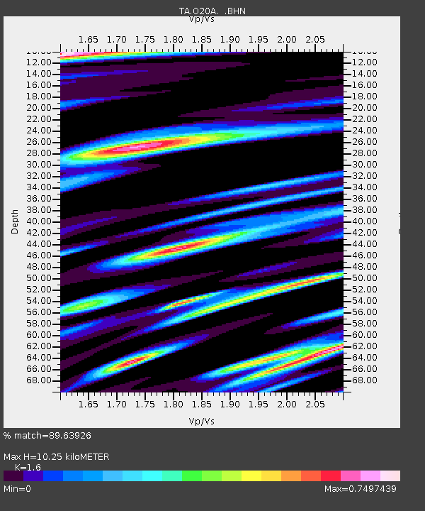
| Estimated Moho Depth: |
10.25 km |
| Estimated Crust Vp/Vs: |
1.60 |
| Assumed Crust Vp: |
6.207 km/s |
| Estimated Crust Vs: |
3.879 km/s |
| Estimated Crust Poisson's Ratio: |
0.18 |
|
| Radial Match: |
89.63926 % |
| Radial Bump: |
400 |
| Transverse Match: |
87.2392 % |
| Transverse Bump: |
400 |
| SOD ConfigId: |
2622 |
| Insert Time: |
2010-03-06 12:41:42.255 +0000 |
| GWidth: |
2.5 |
| Max Bumps: |
400 |
| Tol: |
0.001 |
|

Signal To Noise
| Channel | StoN | STA | LTA |
| TA:O20A: :BHN:20090912T20:14:18.198992Z | 5.195612 | 1.0951762E-6 | 2.1078868E-7 |
| TA:O20A: :BHE:20090912T20:14:18.198992Z | 0.93929064 | 2.3409098E-7 | 2.4922102E-7 |
| TA:O20A: :BHZ:20090912T20:14:18.198992Z | 1.7918193 | 3.5913027E-7 | 2.0042773E-7 |
| Arrivals |
| Ps | 1.1 SECOND |
| PpPs | 4.0 SECOND |
| PsPs/PpSs | 5.1 SECOND |


