You are here: Home > Network List > TA - USArray Transportable Network (new EarthScope stations) Stations List
> Station O20A White River City, CO, USA > Earthquake Result Viewer
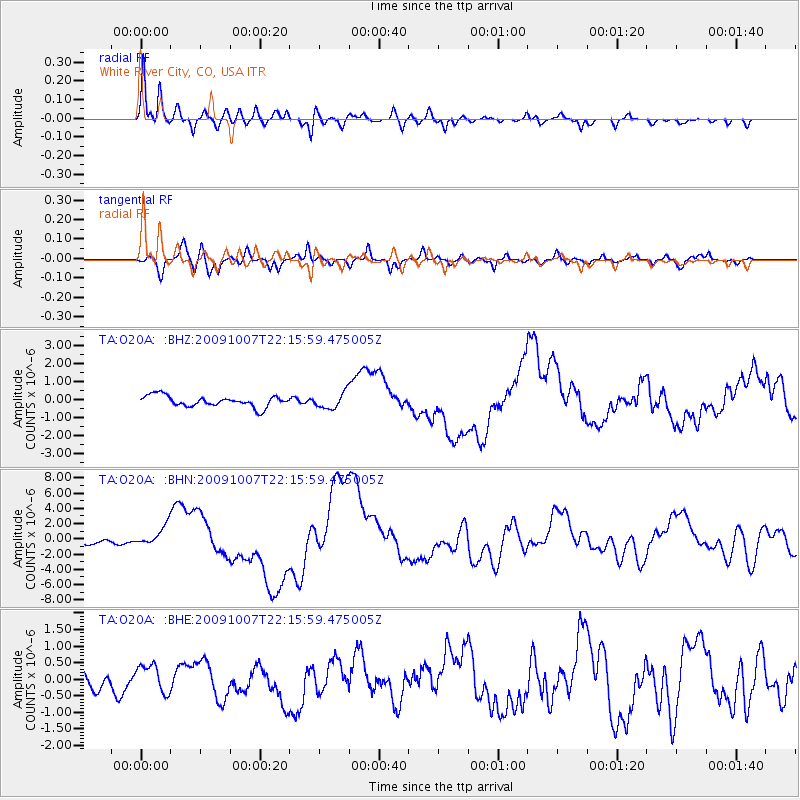
O20A White River City, CO, USA - Earthquake Result Viewer

| Earthquake location: |
Vanuatu Islands |
| Earthquake latitude/longitude: |
-13.0/166.5 |
| Earthquake time(UTC): |
2009/10/07 (280) 22:03:14 GMT |
| Earthquake Depth: |
45 km |
| Earthquake Magnitude: |
6.4 MB, 7.3 MS, 7.6 MW, 7.7 MW |
| Earthquake Catalog/Contributor: |
WHDF/NEIC |
|
| Network: |
TA USArray Transportable Network (new EarthScope stations) |
| Station: |
O20A White River City, CO, USA |
| Lat/Lon: |
40.13 N/108.24 W |
| Elevation: |
1915 m |
|
| Distance: |
94.7 deg |
| Az: |
50.048 deg |
| Baz: |
257.054 deg |
| Ray Param: |
0.04095799 |
| Estimated Moho Depth: |
53.0 km |
| Estimated Crust Vp/Vs: |
1.70 |
| Assumed Crust Vp: |
6.207 km/s |
| Estimated Crust Vs: |
3.662 km/s |
| Estimated Crust Poisson's Ratio: |
0.23 |
|
| Radial Match: |
93.096504 % |
| Radial Bump: |
400 |
| Transverse Match: |
71.78162 % |
| Transverse Bump: |
400 |
| SOD ConfigId: |
2622 |
| Insert Time: |
2010-03-06 12:41:45.417 +0000 |
| GWidth: |
2.5 |
| Max Bumps: |
400 |
| Tol: |
0.001 |
|
Signal To Noise
| Channel | StoN | STA | LTA |
| TA:O20A: :BHN:20091007T22:15:59.475005Z | 4.828702 | 1.3068088E-6 | 2.7063356E-7 |
| TA:O20A: :BHE:20091007T22:15:59.475005Z | 1.4999465 | 4.2609082E-7 | 2.8407067E-7 |
| TA:O20A: :BHZ:20091007T22:15:59.475005Z | 1.4475888 | 4.3880166E-7 | 3.031259E-7 |
| Arrivals |
| Ps | 6.1 SECOND |
| PpPs | 23 SECOND |
| PsPs/PpSs | 29 SECOND |


