You are here: Home > Network List > TA - USArray Transportable Network (new EarthScope stations) Stations List
> Station G22K Bettles, AK, USA > Earthquake Result Viewer
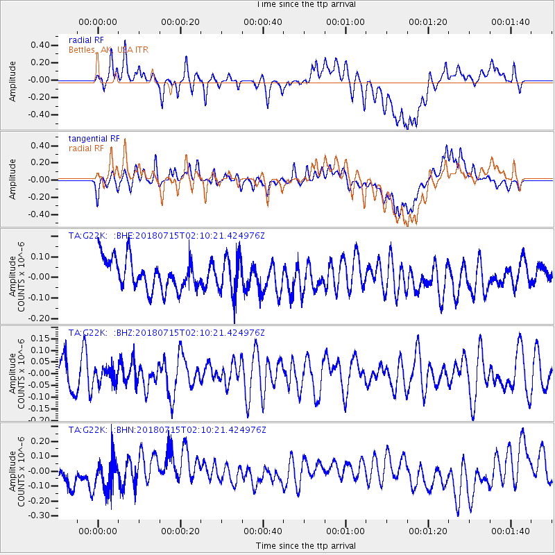
G22K Bettles, AK, USA - Earthquake Result Viewer
*The percent match for this event was below the threshold and hence no stack was calculated.
| Earthquake location: |
Eastern Gulf Of Aden |
| Earthquake latitude/longitude: |
14.1/51.7 |
| Earthquake time(UTC): |
2018/07/15 (196) 01:57:19 GMT |
| Earthquake Depth: |
10 km |
| Earthquake Magnitude: |
6.0 Mww |
| Earthquake Catalog/Contributor: |
NEIC PDE/us |
|
| Network: |
TA USArray Transportable Network (new EarthScope stations) |
| Station: |
G22K Bettles, AK, USA |
| Lat/Lon: |
66.92 N/151.51 W |
| Elevation: |
205 m |
|
| Distance: |
97.5 deg |
| Az: |
9.023 deg |
| Baz: |
337.292 deg |
| Ray Param: |
$rayparam |
*The percent match for this event was below the threshold and hence was not used in the summary stack. |
|
| Radial Match: |
46.343376 % |
| Radial Bump: |
400 |
| Transverse Match: |
45.34039 % |
| Transverse Bump: |
400 |
| SOD ConfigId: |
13570011 |
| Insert Time: |
2019-04-30 13:51:09.116 +0000 |
| GWidth: |
2.5 |
| Max Bumps: |
400 |
| Tol: |
0.001 |
|
Signal To Noise
| Channel | StoN | STA | LTA |
| TA:G22K: :BHZ:20180715T02:10:21.424976Z | 0.5109533 | 3.3232585E-8 | 6.504035E-8 |
| TA:G22K: :BHN:20180715T02:10:21.424976Z | 0.9762991 | 1.0650966E-7 | 1.0909532E-7 |
| TA:G22K: :BHE:20180715T02:10:21.424976Z | 1.1833949 | 8.94044E-8 | 7.554908E-8 |
| Arrivals |
| Ps | |
| PpPs | |
| PsPs/PpSs | |


