You are here: Home > Network List > TA - USArray Transportable Network (new EarthScope stations) Stations List
> Station O20A White River City, CO, USA > Earthquake Result Viewer
O20A White River City, CO, USA - Earthquake Result Viewer
| Earthquake location: |
Honduras |
| Earthquake latitude/longitude: |
15.8/-86.9 |
| Earthquake time(UTC): |
2009/06/08 (159) 05:13:14 GMT |
| Earthquake Depth: |
10 km |
| Earthquake Magnitude: |
5.5 MB, 4.9 MS, 5.4 MW, 5.4 MW |
| Earthquake Catalog/Contributor: |
WHDF/NEIC |
|
| Network: |
TA USArray Transportable Network (new EarthScope stations) |
| Station: |
O20A White River City, CO, USA |
| Lat/Lon: |
40.13 N/108.24 W |
| Elevation: |
1915 m |
|
| Distance: |
30.6 deg |
| Az: |
326.677 deg |
| Baz: |
136.381 deg |
| Ray Param: |
0.07929591 |
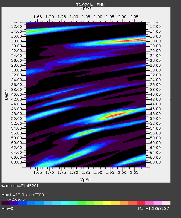
| Estimated Moho Depth: |
17.0 km |
| Estimated Crust Vp/Vs: |
2.10 |
| Assumed Crust Vp: |
6.207 km/s |
| Estimated Crust Vs: |
2.959 km/s |
| Estimated Crust Poisson's Ratio: |
0.35 |
|
| Radial Match: |
81.45201 % |
| Radial Bump: |
400 |
| Transverse Match: |
72.79868 % |
| Transverse Bump: |
400 |
| SOD ConfigId: |
2648 |
| Insert Time: |
2010-03-06 12:41:55.189 +0000 |
| GWidth: |
2.5 |
| Max Bumps: |
400 |
| Tol: |
0.001 |
|
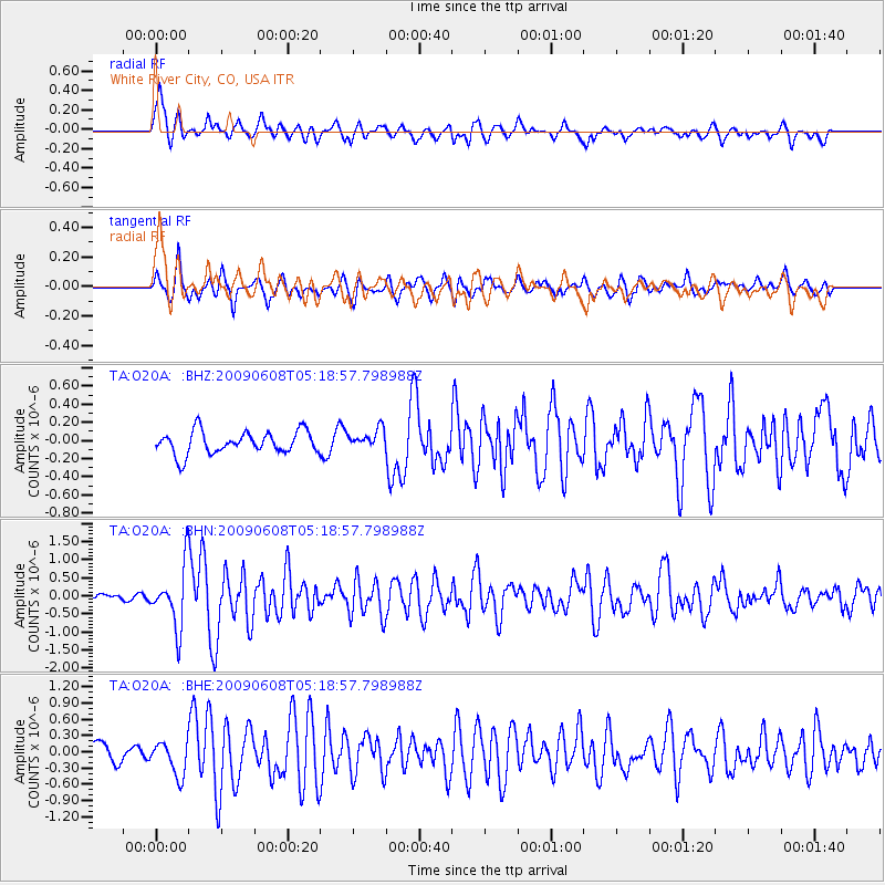
Signal To Noise
| Channel | StoN | STA | LTA |
| TA:O20A: :BHN:20090608T05:18:57.798988Z | 6.447377 | 8.3582466E-7 | 1.2963794E-7 |
| TA:O20A: :BHE:20090608T05:18:57.798988Z | 1.8302627 | 3.1124958E-7 | 1.7005733E-7 |
| TA:O20A: :BHZ:20090608T05:18:57.798988Z | 0.87655276 | 1.08291054E-7 | 1.2354197E-7 |
| Arrivals |
| Ps | 3.2 SECOND |
| PpPs | 8.0 SECOND |
| PsPs/PpSs | 11 SECOND |


