You are here: Home > Network List > TA - USArray Transportable Network (new EarthScope stations) Stations List
> Station O20A White River City, CO, USA > Earthquake Result Viewer
O20A White River City, CO, USA - Earthquake Result Viewer
| Earthquake location: |
Windward Islands |
| Earthquake latitude/longitude: |
15.0/-61.3 |
| Earthquake time(UTC): |
2007/11/29 (333) 19:00:19 GMT |
| Earthquake Depth: |
148 km |
| Earthquake Magnitude: |
6.9 MB, 7.4 MW, 7.4 MW |
| Earthquake Catalog/Contributor: |
WHDF/NEIC |
|
| Network: |
TA USArray Transportable Network (new EarthScope stations) |
| Station: |
O20A White River City, CO, USA |
| Lat/Lon: |
40.13 N/108.24 W |
| Elevation: |
1915 m |
|
| Distance: |
47.9 deg |
| Az: |
310.942 deg |
| Baz: |
107.776 deg |
| Ray Param: |
0.0691768 |
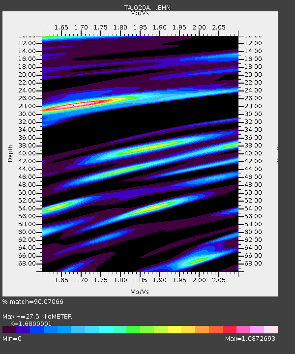
| Estimated Moho Depth: |
27.5 km |
| Estimated Crust Vp/Vs: |
1.68 |
| Assumed Crust Vp: |
6.207 km/s |
| Estimated Crust Vs: |
3.695 km/s |
| Estimated Crust Poisson's Ratio: |
0.23 |
|
| Radial Match: |
90.07066 % |
| Radial Bump: |
400 |
| Transverse Match: |
84.52535 % |
| Transverse Bump: |
400 |
| SOD ConfigId: |
2564 |
| Insert Time: |
2010-03-06 12:42:01.925 +0000 |
| GWidth: |
2.5 |
| Max Bumps: |
400 |
| Tol: |
0.001 |
|
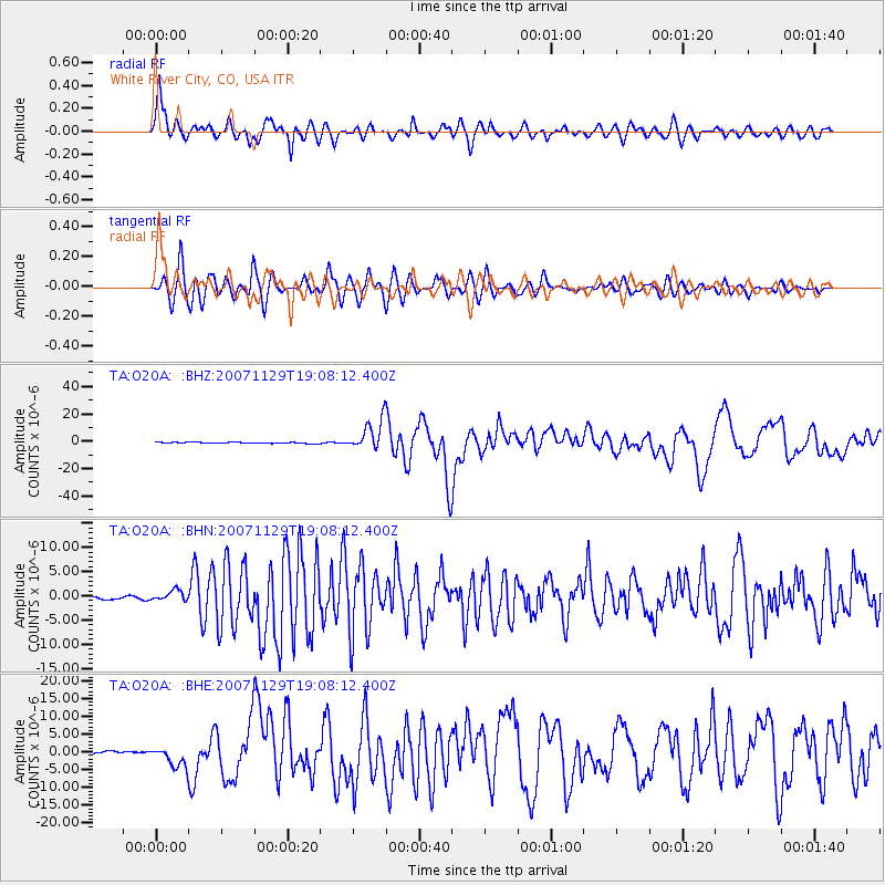
Signal To Noise
| Channel | StoN | STA | LTA |
| TA:O20A: :BHN:20071129T19:08:12.400Z | 4.219552 | 1.0948829E-6 | 2.5947847E-7 |
| TA:O20A: :BHE:20071129T19:08:12.400Z | 10.4487 | 2.8561342E-6 | 2.733483E-7 |
| TA:O20A: :BHZ:20071129T19:08:12.400Z | 26.904049 | 1.112783E-5 | 4.1361173E-7 |
| Arrivals |
| Ps | 3.2 SECOND |
| PpPs | 11 SECOND |
| PsPs/PpSs | 14 SECOND |


