You are here: Home > Network List > TA - USArray Transportable Network (new EarthScope stations) Stations List
> Station O20A White River City, CO, USA > Earthquake Result Viewer
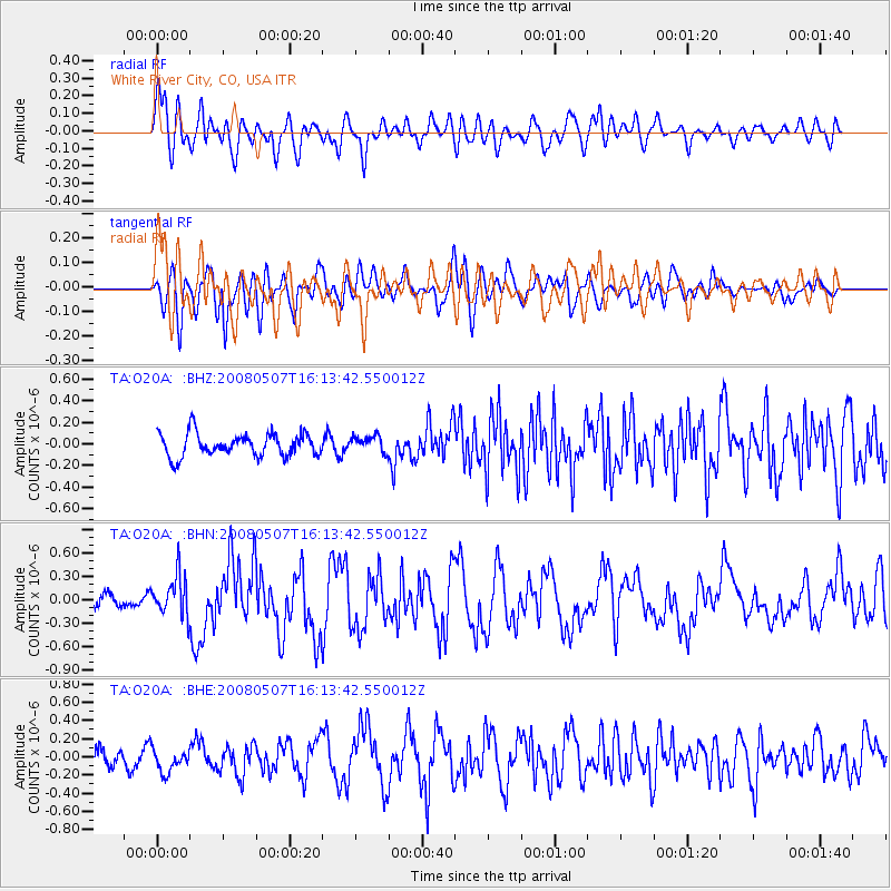
O20A White River City, CO, USA - Earthquake Result Viewer
*The percent match for this event was below the threshold and hence no stack was calculated.
| Earthquake location: |
Near East Coast Of Honshu, Japan |
| Earthquake latitude/longitude: |
36.2/141.5 |
| Earthquake time(UTC): |
2008/05/07 (128) 16:02:02 GMT |
| Earthquake Depth: |
19 km |
| Earthquake Magnitude: |
5.7 MB, 6.2 MW, 6.2 MW |
| Earthquake Catalog/Contributor: |
WHDF/NEIC |
|
| Network: |
TA USArray Transportable Network (new EarthScope stations) |
| Station: |
O20A White River City, CO, USA |
| Lat/Lon: |
40.13 N/108.24 W |
| Elevation: |
1915 m |
|
| Distance: |
80.6 deg |
| Az: |
46.819 deg |
| Baz: |
309.688 deg |
| Ray Param: |
$rayparam |
*The percent match for this event was below the threshold and hence was not used in the summary stack. |
|
| Radial Match: |
67.49808 % |
| Radial Bump: |
400 |
| Transverse Match: |
68.36351 % |
| Transverse Bump: |
400 |
| SOD ConfigId: |
2504 |
| Insert Time: |
2010-03-06 12:42:23.088 +0000 |
| GWidth: |
2.5 |
| Max Bumps: |
400 |
| Tol: |
0.001 |
|
Signal To Noise
| Channel | StoN | STA | LTA |
| TA:O20A: :BHN:20080507T16:13:42.550012Z | 3.7887886 | 2.5955393E-7 | 6.850578E-8 |
| TA:O20A: :BHE:20080507T16:13:42.550012Z | 1.1672328 | 1.3031325E-7 | 1.11642905E-7 |
| TA:O20A: :BHZ:20080507T16:13:42.550012Z | 0.7183463 | 7.677257E-8 | 1.0687404E-7 |
| Arrivals |
| Ps | |
| PpPs | |
| PsPs/PpSs | |


