You are here: Home > Network List > CI - Caltech Regional Seismic Network Stations List
> Station MPP McPhearson Peak > Earthquake Result Viewer
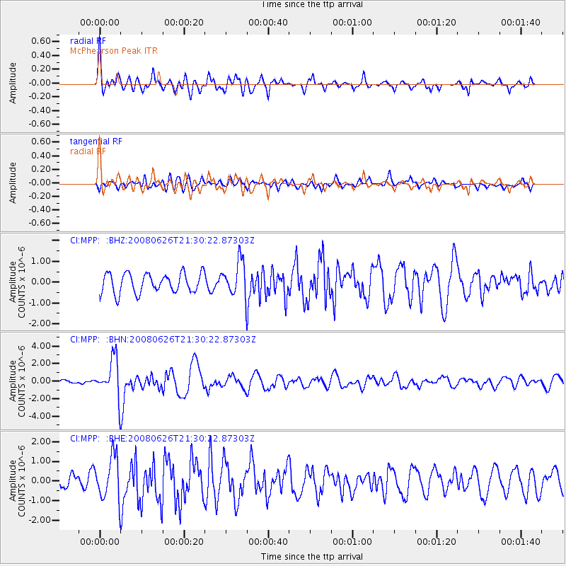
MPP McPhearson Peak - Earthquake Result Viewer
*The percent match for this event was below the threshold and hence no stack was calculated.
| Earthquake location: |
Tonga Islands |
| Earthquake latitude/longitude: |
-20.8/-173.3 |
| Earthquake time(UTC): |
2008/06/26 (178) 21:19:15 GMT |
| Earthquake Depth: |
38 km |
| Earthquake Magnitude: |
6.0 MB, 5.8 MS, 6.2 MW, 6.1 MW |
| Earthquake Catalog/Contributor: |
WHDF/NEIC |
|
| Network: |
CI Caltech Regional Seismic Network |
| Station: |
MPP McPhearson Peak |
| Lat/Lon: |
34.89 N/119.81 W |
| Elevation: |
1739 m |
|
| Distance: |
75.1 deg |
| Az: |
43.154 deg |
| Baz: |
231.132 deg |
| Ray Param: |
$rayparam |
*The percent match for this event was below the threshold and hence was not used in the summary stack. |
|
| Radial Match: |
76.71385 % |
| Radial Bump: |
400 |
| Transverse Match: |
59.69698 % |
| Transverse Bump: |
400 |
| SOD ConfigId: |
2504 |
| Insert Time: |
2010-02-26 02:05:02.196 +0000 |
| GWidth: |
2.5 |
| Max Bumps: |
400 |
| Tol: |
0.001 |
|
Signal To Noise
| Channel | StoN | STA | LTA |
| CI:MPP: :BHN:20080626T21:30:22.87303Z | 9.321205 | 2.2389802E-6 | 2.4020284E-7 |
| CI:MPP: :BHE:20080626T21:30:22.87303Z | 3.3329175 | 1.1240879E-6 | 3.3726846E-7 |
| CI:MPP: :BHZ:20080626T21:30:22.87303Z | 1.8650275 | 8.7117076E-7 | 4.6710878E-7 |
| Arrivals |
| Ps | |
| PpPs | |
| PsPs/PpSs | |


