You are here: Home > Network List > IU - Global Seismograph Network (GSN - IRIS/USGS) Stations List
> Station FURI Mt. Furi, Ethiopia > Earthquake Result Viewer
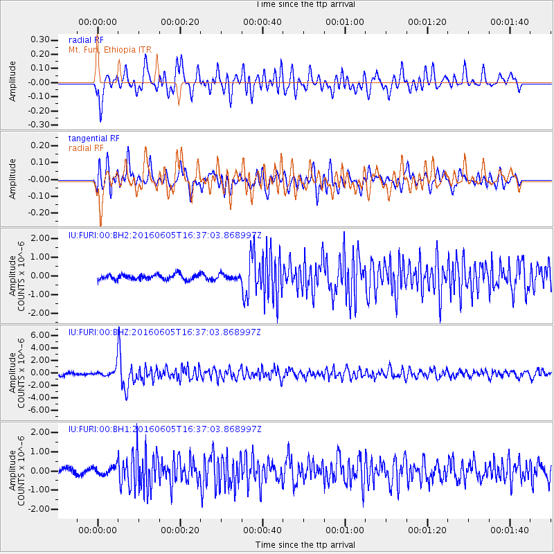
FURI Mt. Furi, Ethiopia - Earthquake Result Viewer
*The percent match for this event was below the threshold and hence no stack was calculated.
| Earthquake location: |
Banda Sea |
| Earthquake latitude/longitude: |
-4.6/125.6 |
| Earthquake time(UTC): |
2016/06/05 (157) 16:25:33 GMT |
| Earthquake Depth: |
429 km |
| Earthquake Magnitude: |
6.3 MWB |
| Earthquake Catalog/Contributor: |
NEIC PDE/NEIC COMCAT |
|
| Network: |
IU Global Seismograph Network (GSN - IRIS/USGS) |
| Station: |
FURI Mt. Furi, Ethiopia |
| Lat/Lon: |
8.90 N/38.68 E |
| Elevation: |
2570 m |
|
| Distance: |
87.7 deg |
| Az: |
279.059 deg |
| Baz: |
94.973 deg |
| Ray Param: |
$rayparam |
*The percent match for this event was below the threshold and hence was not used in the summary stack. |
|
| Radial Match: |
66.17101 % |
| Radial Bump: |
400 |
| Transverse Match: |
64.48679 % |
| Transverse Bump: |
400 |
| SOD ConfigId: |
1609551 |
| Insert Time: |
2016-06-22 15:00:16.260 +0000 |
| GWidth: |
2.5 |
| Max Bumps: |
400 |
| Tol: |
0.001 |
|
Signal To Noise
| Channel | StoN | STA | LTA |
| IU:FURI:00:BHZ:20160605T16:37:03.868997Z | 6.437641 | 1.0274061E-6 | 1.5959357E-7 |
| IU:FURI:00:BH1:20160605T16:37:03.868997Z | 1.52889 | 2.3468704E-7 | 1.5350159E-7 |
| IU:FURI:00:BH2:20160605T16:37:03.868997Z | 0.92497 | 1.3184136E-7 | 1.4253584E-7 |
| Arrivals |
| Ps | |
| PpPs | |
| PsPs/PpSs | |


